
The Coastal Scenery of São Miguel Island, Azores Archipelago: Implications for Coastal Management


Abstract
:1. Introduction
2. Study Area
3. Methods
- Class I (a D value of ≥ 0.85): Extremely attractive natural sites with very high scenic values and no or very low anthropogenic activities.
- Class II (a value of 0.85 > D ≥ 0.65): Attractive natural or semi-natural sites with high scenic values and acceptable anthropogenic activities.
- Class III (a value of 0.65 > D ≥ 0.40): Sites with low scenic interest that are, in some cases, attractive but with obvious anthropogenic activities.
- Class IV (a value of 0.40 > D ≥ 0): Unattractive urban sites with low landscape values and a high presence of anthropogenic activities.
- Class V (a D value of < 0): Urban sites with low landscape value and intensive anthropogenic development.
- Resort areas are generally tourist complexes that can be in any type of environment but have no industrial activities nearby. Resort beaches are usually used by residents staying at the hotel/apartment/camping centers associated with the beach that manages it. They may be open to the public for a fee.
- Urban coastal zones are sites located in the immediate urban environment (city or town) and can therefore serve large communities with well-established public services.
- Village zones are those associated with an urban area that reflects organized but small-scale community services (cafes/bars).
- Rural areas are located outside of the urban environment, and they are not accessible by public transport and have no public service facilities.
- Remote areas are largely defined by their difficult accessibility, either on foot (>300 m) or by boat, and they are not served by public transport and no have public service facilities.
- Sand beaches are beaches that are formed of loose sediments that are less than 4 mm, where the degree of protection to wave fronts is variable and bathing activity takes place in the open sea.
- Pebble beaches are sites consisting of sediments larger than 4 mm.
- Harbors have bathing areas that are the result of harbor or marina structures and are used for bathing activity. In particular, the slopes of the gangways and the area alongside the quays.
- Swimming pools refer to all bathing areas where the water plane is enclosed. They can be natural, semi-natural, or artificial structures. Indeed, in the Azorean Archipelago, most of these areas are made up of lava platforms due to the volcanic origin of the islands.
4. Results: Classification and Distribution of the Investigated Sites
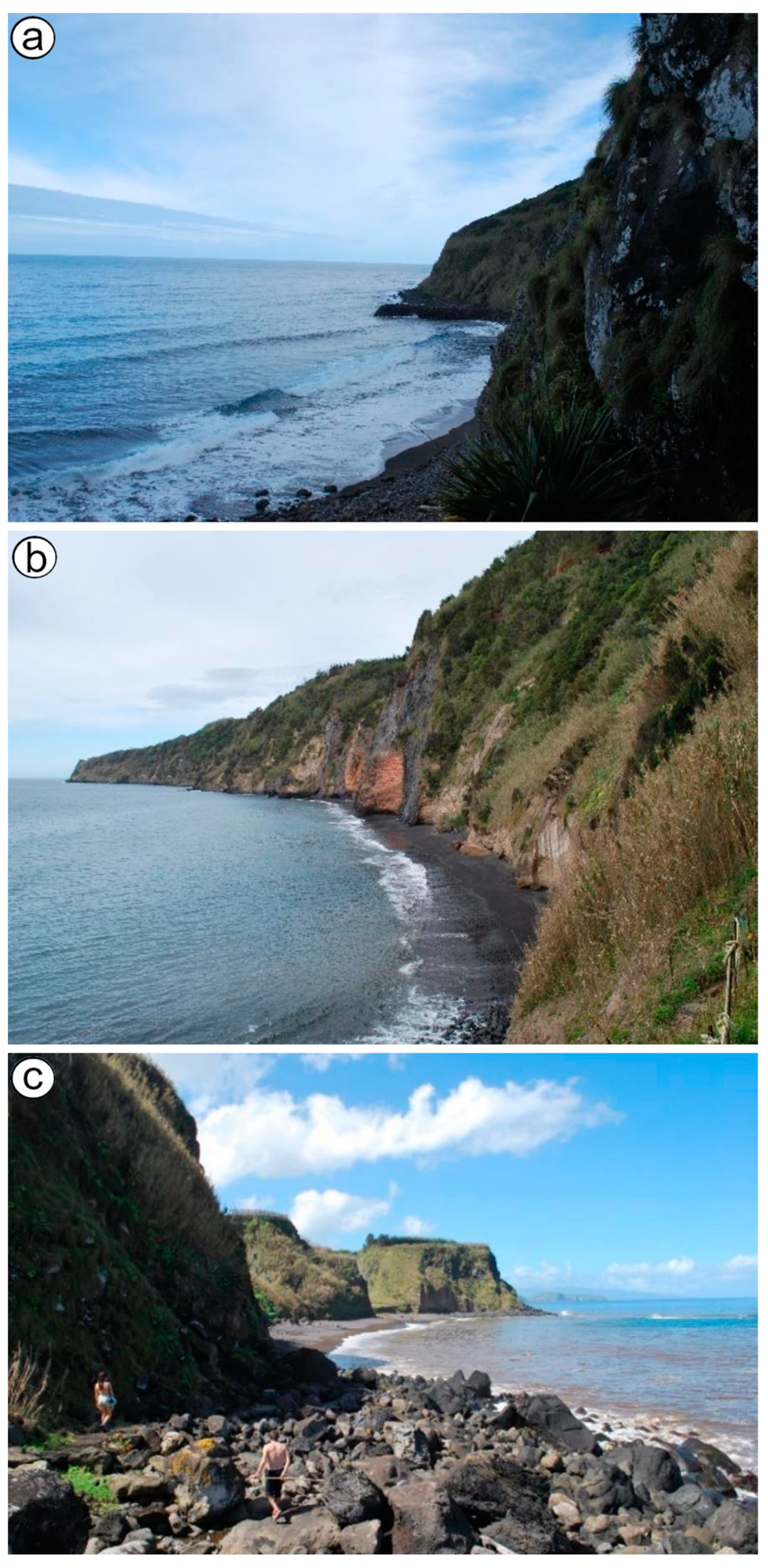
4.1. Class I
4.2. Class II
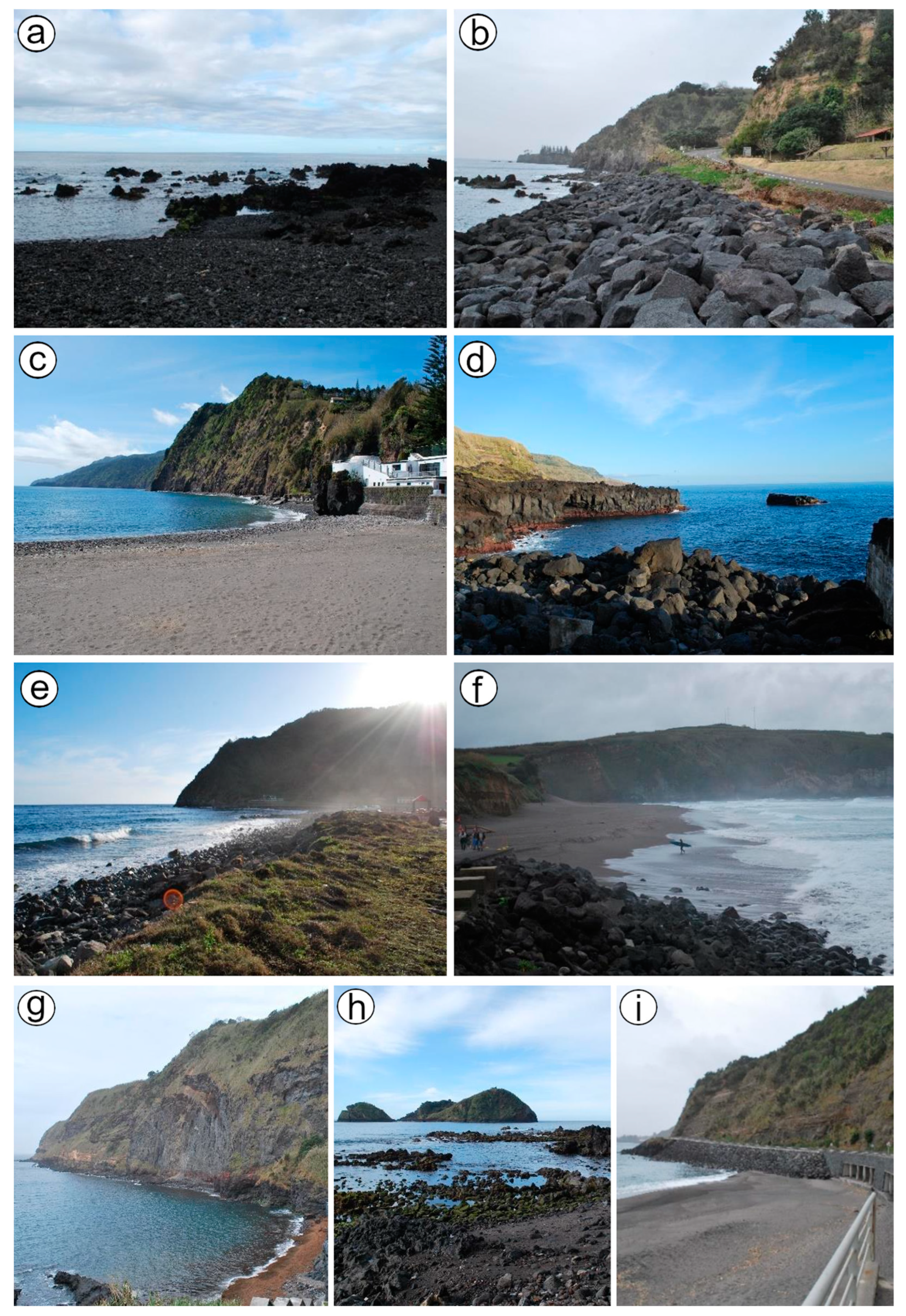
4.3. Class III
4.4. Class IV
4.5. Class V
5. Discussion
5.1. Landscape Assessment in São Miguel
5.1.1. Physical Parameters
5.1.2. Anthropic Parameters
5.2. The Coastal Landscape Classification of São Miguel Island (2009–2022)
5.3. The Azores as a Hub for Coastal Evaluation in Comparison to Other Landscape Assessment Studies
6. Conclusions
Author Contributions
Funding
Institutional Review Board Statement
Informed Consent Statement
Data Availability Statement
Conflicts of Interest
References
- Santos, F.D.; Valente, M.A.; Miranda, P.M.A.; Aguiar, A.; Azevedo, E.B.; Tomé, A.R.; Coelho, F. Climate change scenarios in the Azores and Madeira Islands. World Resour. Rev. 2004, 16, 473–491. [Google Scholar]
- Santos, R.S.; Hawkins, S.; Monteiro, L.R.; Alves, M.; Isidro, E.J. Marine research, resources, and conservation in the Azores. Aquat. Conserv. Mar. Freshw. Ecosyst. 1995, 5, 311–354. [Google Scholar] [CrossRef]
- Borges, P.A.; Amorim, I.R.; Cunha, R.T.D.; Gabriel, R.; Martins, A.M.; Silva, L.; Costa, A.C.; Vieira, V. Azores. In Encyclopedia of Islands; University of California Press: Berkeley, CA, USA, 2009; pp. 70–75. [Google Scholar]
- Williams, A. Definitions and typologies of coastal tourism beach destinations. In Disappearing Destinations: Climate Change and Future Challenges for Coastal Tourism; CABI: Wallingford, UK, 2011; pp. 47–65. [Google Scholar]
- Williams, A.T.; Pond, K.; Ergin, A.; Cullis, M.J. The hazards of beach litter. In Coastal Hazards; Springer: Dordrecht, The Netherlands, 2013; pp. 753–780. [Google Scholar]
- Lencek, L.; Bosker, G. The Beach: A History of Paradise on Earth; Secker (Martin) and Warburg Ltd.: London, UK, 1998. [Google Scholar]
- Honey, M.; Krantz, D. Global Trends in Coastal Tourism; Center on Ecotourism and Sustainable Development: Washington, DC, USA, 2007. [Google Scholar]
- Houston, J.R. The value of Florida beaches. Shore Beach 2013, 81, 4–11. [Google Scholar]
- UNWTO. International Tourism Highlights, 2023 Edition—The Impact of COVID-19 on Tourism (2020–2022); UNWTO: Madrid, Spain, 2023. [Google Scholar]
- Castanho, R.A.; Couto, G.; Pimentel, C.; Carvalho, C.; Áurea, S.; Batista, M.; Naranjo Gómez, J.M. Islas Azores: Una región con un Potencial Significativo para el Desarrollo del Turismo Lento y de Aventura. In Chapter in the Proceddings Book: Actas de las III Jornadas ScienCity; Universidad de Huelva: Huelva, Spain, 2020; ISBN 979-8593513465. [Google Scholar]
- Costa, J.; Rodrigues, D.; Gomes, J. Sustainability of tourism destinations and the importance of certification. Worldw. Hosp. Tour. Themes 2019, 11, 677–684. [Google Scholar] [CrossRef]
- Costa Cristiano, S.; Portz, L.C.; Anfuso, G.; Rockett, G.C.; Barboza, E.G. Coastal scenic evaluation at Santa Catarina (Brazil): Implications for coastal management. Ocean Y Coast. Manag. 2018, 160, 146–157. [Google Scholar] [CrossRef]
- Rangel-Buitrago, N.; Correa, I.D.; Anfuso, G.; Ergin, A.; Williams, A.T. Assessing and managing scenery of the Caribbean Coast of Colombia. Tour. Manag. 2013, 35, 41–58. [Google Scholar] [CrossRef]
- Anfuso, G.; Bolívar-Anillo, H.J.; Asensio-Montesinos, F.; Manzolli, R.P.; Portz, L.; Daza, D.A.V. Beach litter distribution in Admiralty Bay, King George Island, Antarctica. Mar. Pollut. Bull. 2020, 160, 111657. [Google Scholar] [CrossRef]
- Ergin, A.; Karaesmen, E.; Micallef, A.; Williams, A.T. A new methodology for evaluating coastal scenery: Fuzzy logic systems. Area 2004, 36, 367–386. [Google Scholar] [CrossRef]
- Rangel-Buitrago, N.; Williams, A.T.; Ergin, A.; Anfuso, G.; Micallef, A.; Pranzini, E. Coastal scenery: An introduction. In Coastal Scenery: Evaluation and Management; Springer: Berlin/Heidelberg, Germany, 2019; pp. 1–16. [Google Scholar]
- Alcérreca-Huerta, J.C.; Montiel-Hernández, J.R.; Callejas-Jiménez, M.E.; Hernández-Avilés, D.A.; Anfuso, G.; Silva, R. Vulnerability of Subaerial and Submarine Landscapes: The Sand Falls in Cabo San Lucas, Mexico. Land 2020, 10, 27. [Google Scholar] [CrossRef]
- Anfuso, G.; Williams, A.T.; Martínez, G.C.; Botero, C.M.; Hernández, J.C.; Pranzini, E. Evaluation of the scenic value of 100 beaches in Cuba: Implications for coastal tourism management. Ocean Y Coast. Manag. 2017, 142, 173–185. [Google Scholar] [CrossRef]
- Lizarbe-Palacios, M.; Aponte, H.; Botero, C.M. Multitemporal Scenic Evaluation of Urban Coastal Sites: A Peruvian Case Study. Water 2022, 14, 2336. [Google Scholar] [CrossRef]
- Rangel-Buitrago, N.; Contreras-Lopez, M.; Martinez, C.; Williams, A. Can coastal scenery be managed? The Valparaíso region, Chile as a case study. Ocean Coast. Manag. 2018, 163, 383–400. [Google Scholar] [CrossRef]
- Ergin, A.; Micallef, A.; Williams, A.T. Coastal scenic evaluation of Gozo/Comino, Malta, as a tourism product. In Proceedings of the International Pluridisciplinary Conference “The Littoral: Challenge, Dialogue, Action”, Lille, France, 16–18 January 2008. [Google Scholar]
- Ergin, A.; Özölçer, İ.H.; Şahin, F. Evaluating coastal scenery using fuzzy logic: Application at selected sites in Western Black Sea coastal region of Turkey. Ocean Eng. 2010, 37, 583–591. [Google Scholar] [CrossRef]
- Khattabi, A.; Williams, A.T.; Ergin, A. Assessment of quality and attraction of the sandy beaches of Nador province-Morocco. Sandy Beaches Beaches Coast. Zone Manag. 2009, 6, 59. [Google Scholar]
- Williams, A.T.; Khattabi, A. Beach scenery at nador province, Morocco. J. Coast. Conserv. 2015, 19, 743–755. [Google Scholar] [CrossRef]
- Williams, A.T.; Mooser, A.; Anfuso, G.; Herbert, V.; Aucelli, P.P. Coastal scenic assessment in northern France: An attempt to quantify scenic beauty and analyse the role played by the Conservatoire du littoral. Ocean Coast. Manag. 2023, 236, 106446. [Google Scholar] [CrossRef]
- Williams, A.T.; Micallef, A.; Anfuso, G.; Gallego-Fernández, J.B. Andalusia, Spain: An assessment of coastal scenery. Landsc. Res. 2012, 37, 327–349. [Google Scholar] [CrossRef]
- Iglesias, B.; Anfuso, G.; Uterga, A.; Arenas, P.; Williams, A.T. Scenic value of the Basque Country and Catalonia coasts (Spain): Impacts of tourist occupation. J. Coast. Conserv. 2018, 22, 247–261. [Google Scholar] [CrossRef]
- Asensio-Montesinos, F.; Anfuso, G.; Corbí, H. Coastal scenery and litter impacts at Alicante (SE Spain): Management issues. J. Coast. Conserv. 2019, 23, 185–201. [Google Scholar] [CrossRef]
- Mooser, A.; Anfuso, G.; Gómez-Pujol, L.; Rizzo, A.; Williams, A.T.; Aucelli, P.P. Coastal Scenic Beauty and Sensitivity at the Balearic Islands, Spain: Implication of Natural and Human Factors. Land 2021, 10, 456. [Google Scholar] [CrossRef]
- Quintela, A.; Calado, H.; Silva, C.D. Bathing user’s perceptions and expectations of Sao Miguel (Azores) Bathing Areas—A pilot study. J. Coast. Res. 2009, 56, 1145–1149. [Google Scholar]
- Quintela, A.; Silva, C.P.; Calado, H.; Williams, A. The relation of litter with bathing areas typologies, number of users and scenic value. The case study of São Miguel (Azores). J. Coast. Conserv. 2012, 16, 575–584. [Google Scholar] [CrossRef]
- Europea, U. Council of Europe. Retos de la Política Social en las Sociedades Europeas que Envejecen; Comisión Europea: Brussels, Belgium, 2003.
- Falcão, A.D.O. The shoreline OWC wave power plant at the Azores. In Proceedings of the 4th European Wave Energy Conference, Aalborg, Denmark, 4–6 December 2000; pp. 42–47. [Google Scholar]
- Williams, A.T.; Micallef, A. Beach Management: Principles and Practice; Earthscan: London, UK, 2009; p. 480. ISBN 978-1-84407-435-8. [Google Scholar]
- Micallef, A.; Williams, A.T. Application of a novel approach to beach classification in the Maltese Islands. Ocean Y Coast. Manag. 2004, 47, 225–242. [Google Scholar] [CrossRef]
- Moniz, F.; Simão, J. A perceção dos stakeholders sobre o desenvolvimento turístico: O caso da Ilha de São Miguel, Açores. Rev. De Tur. Y Patrim. Cult. 2019, 17, 975–988. [Google Scholar] [CrossRef]
- Rousseau, J.J. Les Rêveries du Promeneur Solitaire; Librairie Droz: Genève, Switzerland, 1948; Volume 43, p. 154. [Google Scholar]
- Nunes, J.C. Novos conceitos em vulcanologia: Erupções, produtos e paisagens vulcânicas. Associação Portuguesa de Geólogos. Geonovas 2002, 16, 5–22. [Google Scholar]
- Lima, E.A.; Machado, M.; Guerreiro, M.; Nunes, J.C.; Costa, M.P. Geological heritage management in small islands: The example of the Azores UNESCO Global Geopark (Portugal). Geoheritage 2018, 10, 659–671. [Google Scholar] [CrossRef]
- Pranzini, E.; Vitale, G. Beach sand colour: The need for a standardised assessment procedure. J. Coast. Res. 2011, 61, 66–69. [Google Scholar] [CrossRef]
- Pranzini, E.; Simonetti, D.; Vitale, G. Sand colour rating and chromatic compatibility of borrow sediments. J. Coast. Res. 2010, 26, 798–808. [Google Scholar] [CrossRef]
- Pranzini, E.; Anfuso, G.; Botero, C.M.; Cabrera, A.; Campos, Y.A.; Martinez, G.C.; Williams, A.T. Sand colour at Cuba and its influence on beach nourishment and management. Ocean Coast. Manag. 2016, 126, 51–60. [Google Scholar] [CrossRef]
- Phillips, M.R.; Borges, P.; Thomas, T.; August, P.; Calado, H.; Veloso-Gomes, F. Maintaining a way of life for São Miguel Island (the Azores archipelago, Portugal): An assessment of coastal processes and protection. Sci. Total Environ. 2014, 481, 142–156. [Google Scholar]
- Ricardo, R.P.; Madeira, M.V.; Medina, J.M.; Marques, M.M.; Furtado, A.F.A. Esboço pedológico da ilha de São Miguel (Açores). An. Do Inst. Super. De Agron. 1977, 37, 275. [Google Scholar]
- Faria, J. Rugulopteryx Okamurae: A Alga «Silenciosa» Chega aos Açores. In Açoriano Oriental, Açores Magazine, Uaciência; Repositório da Universidade dos Açores: Ponta Delgada, Portugal, 2021; pp. 10–11. [Google Scholar]
- Sánchez, N. Clima y Medioambiente: “La Invasión Silenciosa que Pone en Peligro el Mediterráneo Español”; El País: Madrid, Spain, 2021. [Google Scholar]
- Nunes, J.C. The Azores Archipelago: Islands of geodiversity. In Volcanic Tourist Destinations; Springer: Berlin/Heidelberg, Germany, 2014; pp. 57–67. [Google Scholar]
- Lima, E.A.; Nunes, J.C.; Costa, M.P.; Machado, M. Basis for the geological heritage management in the Azores Archipelago (Portugal). Rev. De Gestão Costeira Integr. J. Integr. Coast. Zone Manag. 2014, 14, 301–319. [Google Scholar] [CrossRef]
- Pham, C.K.; Pereira, J.M.; Frias, J.P.; Ríos, N.; Carriço, R.; Juliano, M.; Rodríguez, Y. Beaches of the Azores archipelago as transitory repositories for small plastic fragments floating in the North-East Atlantic. Environ. Pollut. 2020, 263, 114494. [Google Scholar] [CrossRef] [PubMed]
- Woodall, L.C.; Sanchez-Vidal, A.; Canals, M.; Paterson, G.L.; Coppock, R.; Sleight, V.; Thompson, R.C. The deep sea is a major sink for microplastic debris. R. Soc. Open Sci. 2014, 1, 140317. [Google Scholar] [CrossRef] [PubMed]
- Mestanza, C.; Botero, C.M.; Anfuso, G.; Chica-Ruiz, J.A.; Pranzini, E.; Mooser, A. Beach litter in Ecuador and the Galapagos islands: A baseline to enhance environmental conservation and sustainable beach tourism. Mar. Pollut. Bull. 2019, 140, 573–578. [Google Scholar] [CrossRef] [PubMed]
- Lavers, J.L.; Bond, A.L. Exceptional and rapid accumulation of anthropogenic debris on one of the world’s most remote and pristine islands. Proc. Natl. Acad. Sci. USA 2017, 114, 6052–6055. [Google Scholar] [CrossRef] [PubMed]
- Rull, V.; Lara, A.; Rubio-Inglés, M.J.; Giralt, S.; Gonçalves, V.; Raposeiro, P.; Sáez, A. Vegetation and landscape dynamics under natural and anthropogenic forcing on the Azores Islands: A 700-year pollen record from the São Miguel Island. Quat. Sci. Rev. 2017, 159, 155–168. [Google Scholar] [CrossRef]
- Williams, A.T.; Pond, K.; Philipp, R. Aesthetic Aspects, 1st ed.; Bartram, J., Rees, G., Eds.; CRC Press: London, UK, 1999; p. 352. [Google Scholar] [CrossRef]
- Ponte, J.; Couto, G.; Pimentel, P.; Sousa, Á.; Oliveira, A. Tourist satisfaction with the Municipality of Ponta Delgada (Azores). Rev. De Gestão E Secr. 2019, 10, 192–217. [Google Scholar] [CrossRef]
- Rangel-Buitrago, N. (Ed.) Coastal Scenery: Evaluation and Management; Springer: Berlin/Heidelberg, Germany, 2018; Volume 26. [Google Scholar]
- Mestanza-Ramón, C.; Anfuso, G.; Chica-Ruiz, J.A.; Mooser, A.; Botero, C.M.; Pranzini, E. Coastal Scenic Evaluation of Continental Ecuador and Galapagos Islands: Human Impacts and Management Issues. J. Mar. Sci. Eng. 2020, 8, 468. [Google Scholar] [CrossRef]


| N | Physical Parameters | Rating | |||||
|---|---|---|---|---|---|---|---|
| 1 | 2 | 3 | 4 | 5 | |||
| 1 | Height (m) | Absent | 5–30 m | 31–60 m | 61–90 m | >90 m | |
| 2 | CLIFF | Slope (°) | Absent | >45° | circa 60° | circa 75° | circa vertical |
| 3 | Special features * | Absent | 1 | 2 | 3 | Many (>3) | |
| 4 | Type | Absent | Mud | Cobble/Boulder | Pebble/Gravel | Sand | |
| 5 | BEACH FACE | Width (m) | Absent | ≤5 > 100 | >5 ≤ 25 | >25 ≤ 50 | >50 ≤ 100 |
| 6 | Color | Absent | Dark | Dark tan | Light tan/bleached | White/gold | |
| 7 | Slope (°) | Absent | <5° | 5°–10° | 10°–20° | 20°–45° | |
| 8 | ROCKY SHORE | Extent (m) | Absent | < 5 m | 5–10 m | 10–20 m | >20 m |
| 9 | Roughness | Absent | Distinctly jagged | Deeply pitted and/or irregular | Shallow-pitted | Smooth | |
| 10 | DUNES | Absent | Remnants | Fore dune | Secondary ridge | Several | |
| 11 | VALLEY | Absent | Dry valley | (<1 m) Stream | (1–4 m) Stream | River/limestone gorge | |
| 12 | SKYLINE LANDFORM | Not visible | Flat | Undulating | Highly undulating | Mountainous | |
| 13 | TIDES | Macro (>4 m) | Meso (2–4 m) | Micro (<2 m) | |||
| 14 | COASTAL LANDSCAPE FEATURES ** | None | 1 | 2 | 3 | >3 | |
| 15 | VISTAS | Open on one side | Open on two sides | Open on three sides | Open on four sides | ||
| 16 | WATER COLOR AND CLARITY | Muddy brown/gray | Milky blue/green/opaque | Green/gray/blue | Clear blue//dark blue | Very clear turquoise | |
| 17 | NATURAL VEGETATION COVER | Bare (<10% vegetation only) | Scrub/garigue (marram/gorse, bramble, etc.) | Wetlands/meadow | Coppices, maquis (±mature trees) | Varity of mature trees/mature natural cover | |
| 18 | VEGETATION DEBRIS | Continuous (>50 cm high) | Full strand line | Single-accumulation | Few scattered items | None | |
| Human parameters | |||||||
| 19 | NOISE DISTURBANCE | Intolerable | Tolerable | Little | None | ||
| 20 | LITTER | Continuous accumulations | Full strand line | Single-accumulation | A few scattered items | Virtually absent | |
| 21 | SEWAGE DISCHARGE EVIDENCE | Sewage evidence | Same evidence (1–3 items) | No evidence of sewage | |||
| 22 | NON_BUILT ENVIRONMENT | None | Hedgerow/terracing/monoculture | Field mixed cultivation ± trees/natural | |||
| 23 | BUILT ENVIRONMENT *** | Heavy industry | Heavy tourism and/or urban | Light tourism and/or urban and/or sensitive | Sensitive tourism and/or urban | Historic and/or none | |
| 24 | ACCESS TYPE | No buffer zone/heavy traffic | No buffer zone/light traffic | Parking lot visible from coastal area | Parking lot not visible from coastal area | ||
| 25 | SKYLINE | Very unattractive | Sensitively designed high/low | Very sensitively designed | Natural/historic features | ||
| 26 | UTILITIES **** | >3 | 3 | 2 | 1 | None |
| Sites (Number Indicates Location in Figure 1b) | Geographical Coordinates | D Value | Class | Type | Characteristics |
|---|---|---|---|---|---|
| Lombo Gordo (20) | 37°47′12.07″ N/25°8′28.59″ W | 0.92 | I | Remote | Sand |
| Praia d’Amora (16) | 37°43′29.90″ N/25°20′56.82″ W | 0.88 | I | Remote | Sand |
| Viola (23) | 37°50′19.41″ N/25°22′3.54″ W | 0.87 | I | Remote | Sand |
| Ribeira das Tainhas (15) | 37°42′58.27″ N/25°24′36.59″ W | 0.81 | II | Rural | Sand |
| Maia (24) | 37°50′0.44″ N/25°23′11.94″ W | 0.72 | II | Rural | Sand |
| Praia Santana (28) | 37°48′51.94″ N/25°33′37.43″ W | 0.68 | II | Rural | Sand |
| Praia do Degredo (11) | 37°42′59.81″ N/25°27′21.34″ W | 0.66 | II | Remote | Sand |
| Da Boca De Ribeira (21) | 37°50′43.73″ N/25°8′48.79″ W | 0.58 | III | Rural | Pool |
| Zona Balnear da Foz das Coelhas (22) | 37°51′17.07″ N/25°17′46.39″ W | 0.52 | III | Rural | Pebbles |
| Praia Pequena Água d’Alto (9) | 37°43′5.12″ N/25°28′53.57″ W | 0.51 | III | Village | Sand |
| Ribeira Quente (17) | 37°43′49.81″ N/25°18′34.34″ W | 0.49 | III | Urban | Sand |
| Praia dos Moinhos (25) | 37°49′24.78″ N/25°26′45.31″ W | 0.47 | III | Village | Sand |
| Poços das Calhetas (29) | 37°49′26.52″ N/25°36′22.23″ W | 0.31 | IV | Rural | Pool |
| Local Água d’Alto (8) | 37°42′56.57″ N/25°29′11.82″ W | 0.25 | IV | Village | Pebbles |
| Povoação (18) | 37°44′47.98″ N/25°14′56.83″ W | 0.21 | IV | Urban | Sand |
| Porto Dos Batéis Feterias (1) | 37°48′13.22″ N/25°48′8.71″ W | 0.20 | IV | Rural | Pool |
| Faial da Terra (19) | 37°44′29.12″ N/25°11′33.88″ W | 0.19 | IV | Village | Pebbles |
| Santa Bárbara (27) | 37°49′8.19″ N/25°32′30.60″ W | 0.13 | IV | Village | Sand |
| Baixa d’Areia (6) | 37°43′2.41″ N/25°31′7.24″ W | 0.13 | IV | Village | Pebbles |
| Ilhéu de Vila Franca do Campo (12) | 37°42′45.08″ N/25°26′31.27″ W | 0.03 | IV | Village | Pebbles |
| Praia Grande Água d’Alto (10) | 37°42′59.92″ N/25°28′26.58″ W | 0.02 | IV | Rural | Sand |
| Pópulo (4) | 37°44′59.59″ N/25°37′5.58″ W | −0.03 | V | Urban | Sand |
| Milicias (3) | 37°45′1.08″ N/25°37′24.65″ W | −0.17 | V | Urban | Sand |
| Monte Verde (26) | 37°49′18.03″ N/25°31′50.99″ W | −0.33 | V | Urban | Sand |
| Vinha d’Areia (14) | 37°42′59.85″ N/25°25′36.19″ W | −0.36 | V | Urban | Sand |
| Caloura (7) | 37°42′46.90″ N/25°29′43.34″ W | −0.36 | V | Village | Port |
| Porto Vila Franca (13) | 37°42′49.49″ N/25°26′15.12″ W | −0.42 | V | Urban | Port |
| São Roque (2) | 37°44′59.52″ N/25°37′52.72″ W | −0.60 | V | Urban | Sand |
| Lagoa (5) | 37°44′44.10″ N/25°35′50.85″ W | −0.76 | V | Urban | Pebbles |
| Assessed Coastal Sites | D-Value | Class | Typology | ||
|---|---|---|---|---|---|
| 2012 | 2022 | 2012 | 2022 | 2012 and 2022 | |
| Piscina das Feteiras | 0.61 | 0.20 | III | IV | Rural |
| Pópulo | 0.26 | −0.03 | IV | V | Urban |
| Milícias | 0.13 | −0.17 | IV | V | Urban |
| Dos Moinhos | 0.80 | 0.47 | II | III | Village |
| Porto da Caloura | 0.53 | −0.36 | III | V | Village |
| Agua d’Alto | 0.26 | 0.02 | IV | IV | Rural |
| Ribeira Quente | 0.28 | 0.49 | IV | III | Urban |
| Povoação | 0.37 | 0.21 | IV | IV | Urban |
Disclaimer/Publisher’s Note: The statements, opinions and data contained in all publications are solely those of the individual author(s) and contributor(s) and not of MDPI and/or the editor(s). MDPI and/or the editor(s) disclaim responsibility for any injury to people or property resulting from any ideas, methods, instructions or products referred to in the content. |
© 2024 by the authors. Licensee MDPI, Basel, Switzerland. This article is an open access article distributed under the terms and conditions of the Creative Commons Attribution (CC BY) license (https://creativecommons.org/licenses/by/4.0/).
Share and Cite
Tendero-Peiró, C.; Asensio-Montesinos, F.; Anfuso, G.; Corbí, H. The Coastal Scenery of São Miguel Island, Azores Archipelago: Implications for Coastal Management. J. Mar. Sci. Eng. 2024, 12, 707. https://0-doi-org.brum.beds.ac.uk/10.3390/jmse12050707
Tendero-Peiró C, Asensio-Montesinos F, Anfuso G, Corbí H. The Coastal Scenery of São Miguel Island, Azores Archipelago: Implications for Coastal Management. Journal of Marine Science and Engineering. 2024; 12(5):707. https://0-doi-org.brum.beds.ac.uk/10.3390/jmse12050707
Chicago/Turabian StyleTendero-Peiró, Claudia, Francisco Asensio-Montesinos, Giorgio Anfuso, and Hugo Corbí. 2024. "The Coastal Scenery of São Miguel Island, Azores Archipelago: Implications for Coastal Management" Journal of Marine Science and Engineering 12, no. 5: 707. https://0-doi-org.brum.beds.ac.uk/10.3390/jmse12050707