

A Hidden Eruption: The 21 May 2023 Paroxysm of the Etna Volcano (Italy)
 , ,
, ,  ,
,  , , ,
, , ,
Abstract
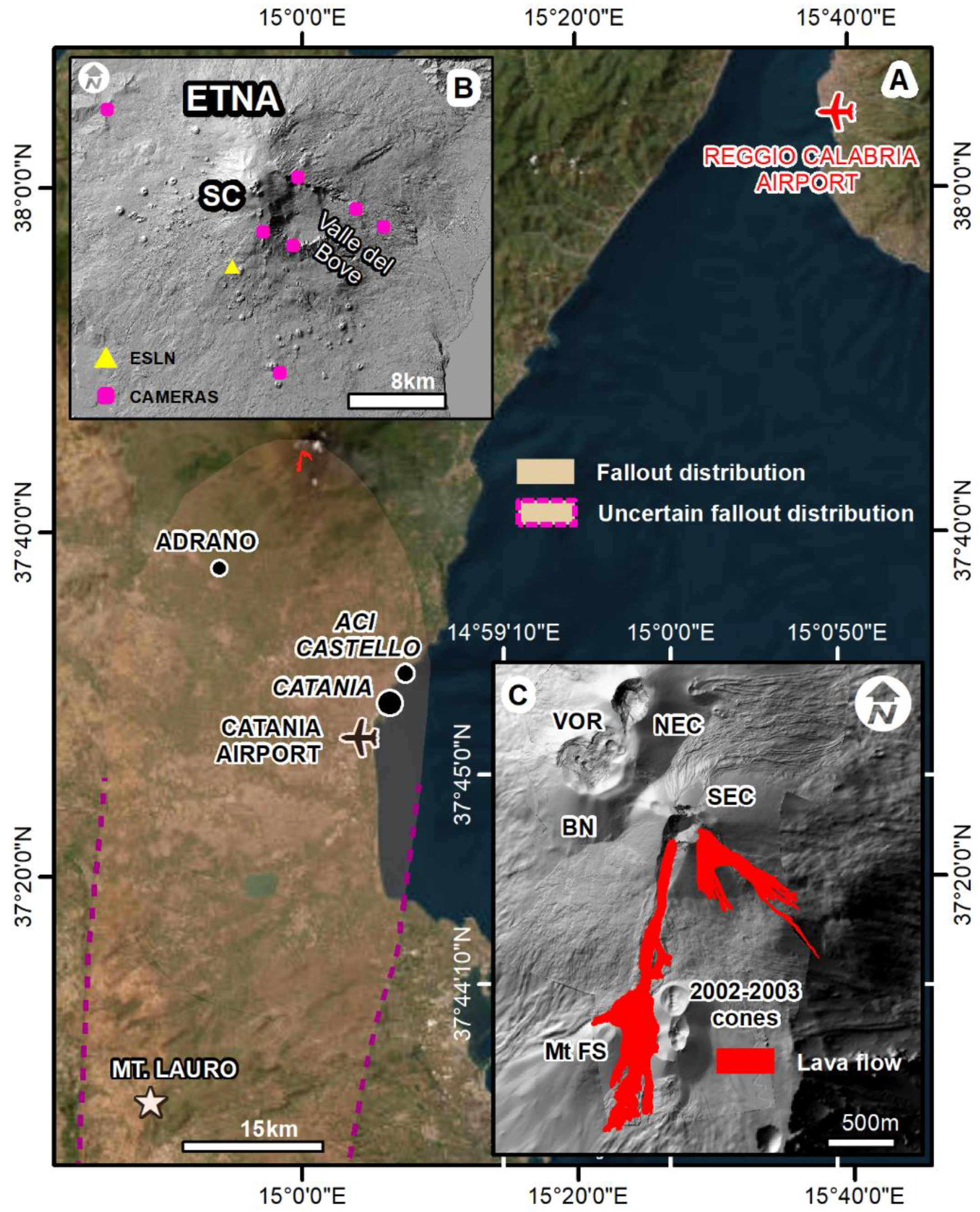
:1. Introduction
The 21 May 2023 Eruption
2. Materials and Methods
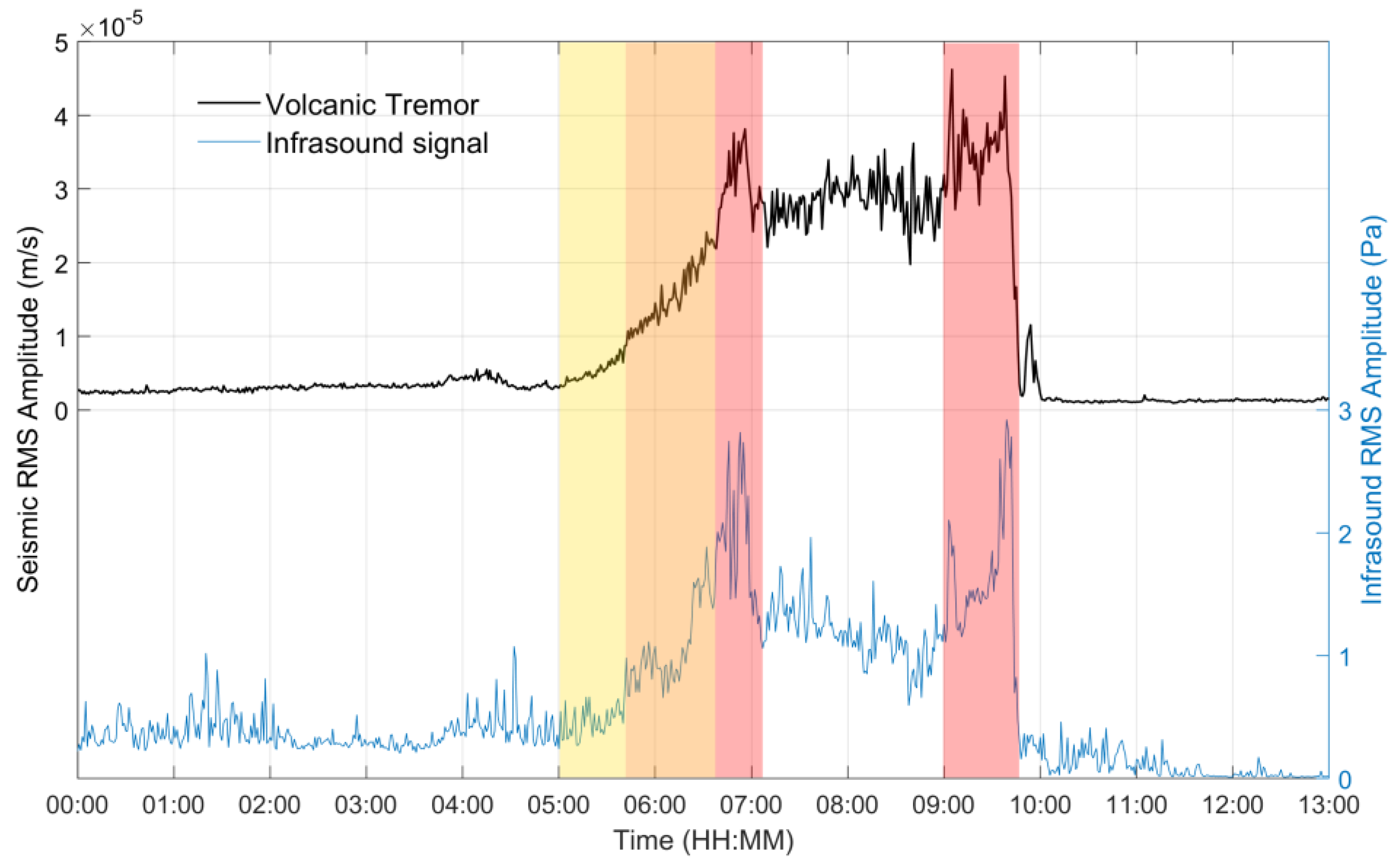
2.1. Volcanic Tremor and Infrasound Signals
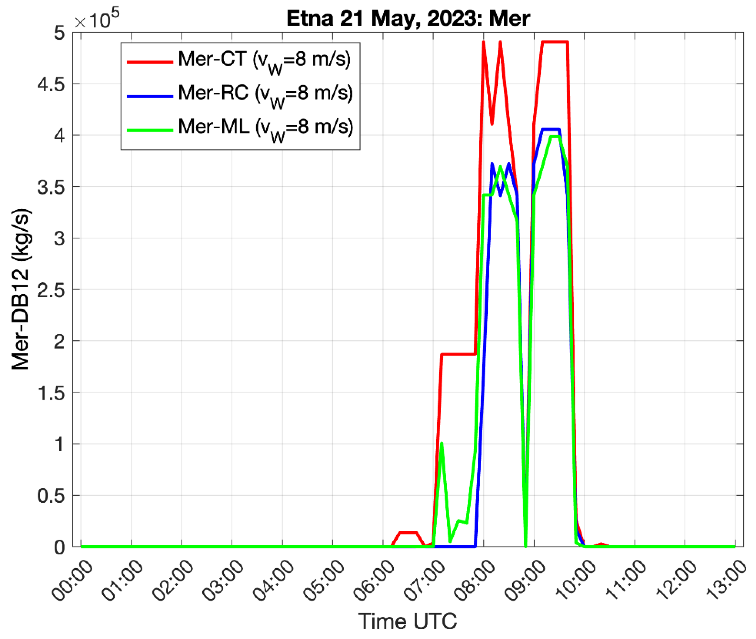
2.2. Radar Signals
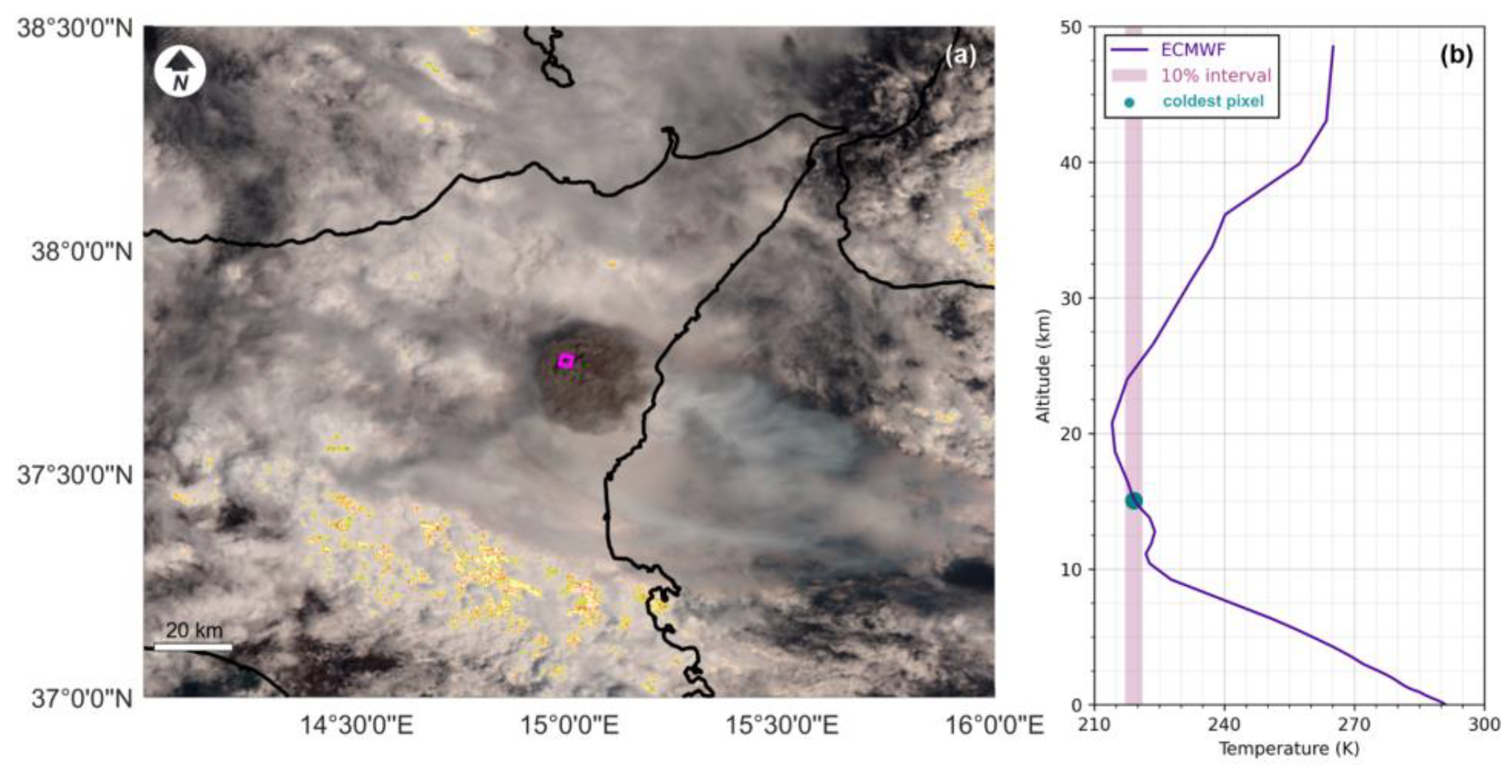
2.3. Satellite Data
2.4. UAS-Acquired Images
2.5. Field Data and Sedimentological Analysis
3. Results
3.1. Volcanic Tremor and Infrasound Signals
3.2. Radar Signals
3.3. Satellite Data
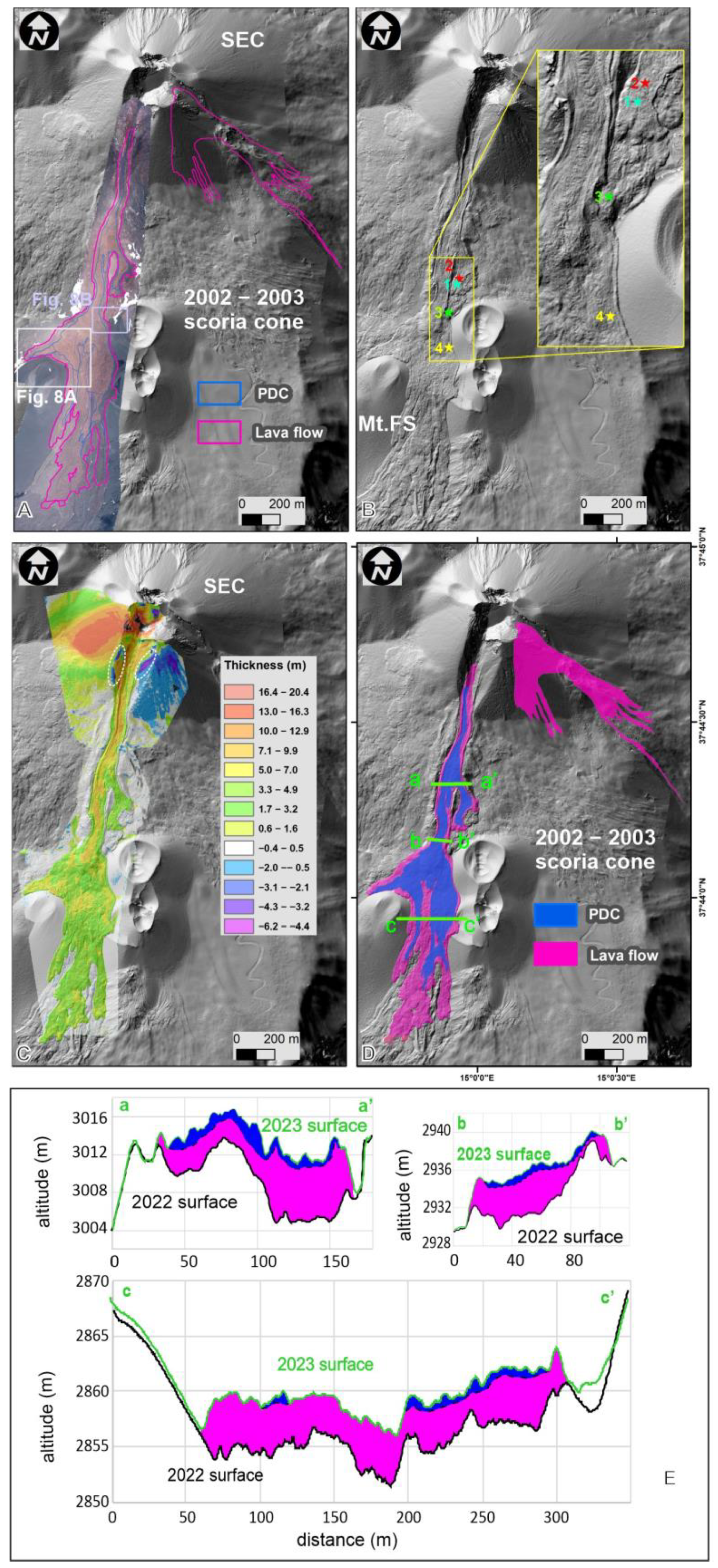
3.4. UAS Data
3.5. Field Data and Sedimentological Analysis
4. Discussion
5. Conclusions
Author Contributions
Funding
Data Availability Statement
Acknowledgments
Conflicts of Interest
References
- Tilling, R.I. Introduction to special section on how volcanoes work: Part 1. J. Geophys. Res. 1987, 92, 13685–13686. [Google Scholar] [CrossRef]
- Andronico, D.; Branca, S.; Calvari, S.; Burton, M.; Caltabiano, T.; Corsaro, R.A.; Del Carlo, P.; Garfì, G.; Lodato, L.; Miraglia, L.; et al. A multi-disciplinary study of the 2002–03 Etna eruption: Insights into a complex plumbing system. Bull. Volcanol. 2005, 67, 314–330. [Google Scholar] [CrossRef]
- Corsaro, R.A.; Andronico, D.; Behncke, B.; Branca, S.; Caltabiano, T.; Ciancitto, F.; Cristaldi, A.; De Beni, E.; La Spina, A.; Lodato, L.; et al. Monitoring the December 2015 summit eruptions of Mt. Etna (Italy): Implications on eruptive dynamics. J. Volcanol. Geotherm. Res. 2017, 341, 53–69. [Google Scholar] [CrossRef]
- Coppola, D.; Laiolo, M.; Cigolini, C.; Massimetti, F.; Delle Donne, D.; Ripepe, M.; Arias, H.; Barsotti, S.; Parra, C.B.; Centeno, G.R.; et al. Thermal remote sensing for global volcano monitoring: Experiences from the MIROVA system. Front. Earth Sci. 2020, 7, 362. [Google Scholar] [CrossRef]
- Cannata, A.; Di Grazia, G.; Montalto, P.; Ferrari, F.; Nunnari, G.; Patanè, D.; Privitera, E. New insights into banded tremor from the 2008–2009 Mount Etna eruption. J. Geophys. Res. Solid Earth 2010, 115, B12318. [Google Scholar] [CrossRef]
- Cannata, A.; Di Grazia, G.; Giuffrida, M.; Gresta, S.; Palano, M.; Sciotto, M.; Viccaro, M.; Zuccarello, F. Space-time evolution of magma storage and transfer at Mt. Etna volcano (Italy): The 2015–2016 reawakening of Voragine crater. Geochem. Geophys. Geosyst. 2018, 19, 471–495. [Google Scholar] [CrossRef]
- Chouet, B.A.; Matoza, R.S. A multi-decadal view of seismic methods for detecting precursors of magma movement and eruption. J. Volcanol. Geotherm. Res. 2013, 252, 108–175. [Google Scholar] [CrossRef]
- McNutt, S.R.; Nishimura, T. Volcanic tremor during eruptions: Temporal characteristics, scaling and constraints on conduit size and processes. J. Volcanol. Geotherm. Res. 2008, 178, 10–18. [Google Scholar] [CrossRef]
- Viccaro, M.; Zuccarello, F.; Cannata, A.; Palano, M.; Gresta, S. How a complex basaltic volcanic system works: Constraints from integrating seismic, geodetic, and petrological data at Mount Etna volcano during the July–August 2014 eruption. J. Geophys. Res. Solid Earth 2016, 121, 5659–5678. [Google Scholar] [CrossRef]
- Sparks, R.S.J.; Biggs, J.; Neuberg, J.W. Monitoring Volcanoes. Science 2012, 335, 1310–1311. [Google Scholar] [CrossRef]
- Almendros, J.; Chouet, B.; Dawson, P. Spatial extent of a hydrothermal system at kilauea volcano, Hawaii, determined from array analyses of shallow long period seismicity: 2. Results. J. Geophys. Res. Solid Earth 2001, 106, 13581–13597. [Google Scholar] [CrossRef]
- Patané, D.; Di Grazia, G.; Cannata, A.; Montalto, P.; Boschi, E. Shallow magma pathway geometry at Mt. Etna volcano. Geochem. Geophys. Geosyst. 2008, 9, 12. [Google Scholar] [CrossRef]
- Viccaro, M.; Garozzo, I.; Cannata, A.; Di Grazia, G.; Gresta, S. Gas burst vs. gas-rich magma recharge: A multidisciplinary study to reveal factors controlling duration of the recent paroxysmal eruptions at Mt. Etna. J. Volcanol. Geotherm. Res. 2014, 278–279, 1–13. [Google Scholar] [CrossRef]
- Alparone, S.; Andronico, D.; Lodato, L.; Sgroi, T. Relationship between tremor and volcanic activity during the Southeast Crater eruption on Mount Etna in early 2000. J. Geophys. Res. 2003, 108, 2241. [Google Scholar] [CrossRef]
- Andronico, D.; Cannata, A.; Di Grazia, G.; Ferrari, F. The 1986–2021 paroxysmal episodes at the summit craters of Mt. Etna: Insights into volcano dynamics and hazard. Earth Sci. Rev. 2021, 220, 103686. [Google Scholar] [CrossRef]
- Gresta, S.; Lombardo, G.; Cristofolini, R. Characteristics of volcanic tremor accompanying the September 24th, 1986 explosive eruption of Mt. Etna (Italy). Ann. Geophys. 1996, 39, 411–420. [Google Scholar] [CrossRef]
- Alparone, S.; Andronico, D.; Sgroi, T.; Ferrari, F.; Lodato, L.; Reitano, D. Alert system to mitigate tephra fallout hazards at Mt. Etna Volcano, Italy. Nat. Hazards 2007, 43, 333–350. [Google Scholar] [CrossRef]
- Cannata, A.; Catania, A.; Alparone, S.; Gresta, S. Volcanic tremor at Mt. Etna: Inferences on magma dynamics during effusive and explosive activity. J. Volcanol. Geotherm. Res. 2008, 178, 19–31. [Google Scholar] [CrossRef]
- La Spina, A.L.; Burton, M.R.; Allard, P.; Alparone, S.; Muré, F. Open-path FTIR spectroscopy of magma degassing processes during eight lava fountains on Mount Etna. Earth Planet. Sci. Lett. 2015, 413, 123–134. [Google Scholar] [CrossRef]
- Andronico, D.; Scollo, S.; Cristaldi, A.; Ferrari, F. Monitoring ash emission episodes at Mt. Etna: The 16 November 2006 case study. J. Volcanol. Geotherm. Res. 2009, 180, 123–134. [Google Scholar] [CrossRef]
- Cannavò, F.; Sciotto, M.; Cannata, A.; Di Grazia, G. An integrated geophysical approach to track magma intrusion: The 2018 Christmas Eve eruption at Mt. Etna. Geophys. Res. Lett. 2019, 46. [Google Scholar] [CrossRef]
- Matoza, R.; Fee, D.; Green, D.; Mialle, P. Volcano infrasound and the international monitoring system. In Infrasound Monitoring for Atmospheric Studies; Le Pichon, A., Blanc, E., Hauchecorne, A., Eds.; Springer: Berlin/Heidelberg, Germany, 2019; pp. 1023–1077. [Google Scholar]
- Sciotto, M.; Watson, L.M.; Cannata, A.; Cantarero, M.; De Beni, E.; Johnson, J. Infrasonic gliding reflects a rising magma column at Mount Etna (Italy). Sci. Rep. 2022, 12, 16954. [Google Scholar] [CrossRef] [PubMed]
- Allstadt, K.E.; Matoza, R.S.; Lockhart, A.B.; Moran, S.C.; Caplan-Auerbach, J.; Haney, M.M.; Thelen, W.A.; Malone, S.D. Seismic and acoustic signatures of surficial mass movements at volcanoes. J. Volcanol. Geotherm. Res. 2018, 364, 76–106. [Google Scholar] [CrossRef]
- McNutt, S.R. Volcanic tremor and its use in estimating eruption parameters. In Proceedings of the 2nd International Conference on Volcanic Ash and Aviation Safety, Alexandria, VA, USA, 21–24 June 2004; Section 2. US Department of Commerce: Washington, DC, USA; NOAA: Washington, DC, USA, 2004; pp. 49–50. [Google Scholar]
- Ripepe, M.; Bonadonna, C.; Folch, A.; Delle Donne, D.; Lacanna, G.; Marchetti, E.; Höskuldsson, A. Ash-plume dynamics and eruption source parameters by infrasound and thermal imagery: The 2010 Eyjafjallajökull eruption. Earth Planet Sci. Lett. 2013, 366, 112–121. [Google Scholar] [CrossRef]
- De Angelis, S.; Diaz-Moreno, A.; Zuccarello, L. Recent developments and applications of acoustic infrasound to monitor volcanic emissions. Remote Sens. 2019, 11, 1302. [Google Scholar] [CrossRef]
- De Angelis, S.; Zuccarello, L.; Scollo, S.; Mereu, L. Assessment of eruption source parameters using infrasound and plume modelling: A case study from the 2021 eruption of Mt. Etna, Italy. Sci. Rep. 2023, 13, 19857. [Google Scholar] [CrossRef] [PubMed]
- Marzano, F.S.; Mereu, L.; Montopoli, M.; Cimini, D.; Martucci, G. Volcanic ash cloud observation using ground-based Ka-band radar and near-infrared Lidar ceilometer during the Eyjafjallajökull eruption. Ann. Geophys. 2015, 57. [Google Scholar] [CrossRef]
- MSG-SEVIRI. Available online: https://www.esa.int/esapub/bulletin/bullet111/chapter4_bul111.pdf (accessed on 4 April 2024).
- Romeo, F.; Mereu, L.; Scollo, S.; Papa, M.; Corradini, S.; Merucci, L.; Marzano, F.S. Volcanic Cloud Detection and Retrieval Using Satellite Multisensor Observations. Remote Sens. 2023, 15, 888. [Google Scholar] [CrossRef]
- De Beni, E.; Cantarero, M.; Neri, M.; Messina, A. Lava flows of Mt Etna, Italy: The 2019 eruption within the context of the last two decades (1999–2019). J. Maps 2021, 17, 65–76. [Google Scholar] [CrossRef]
- Chevrel, M.O.; Villeneuve, N.; Grandin, R.; Froger, J.-L.; Coppola, D.; Massimetti, F.; Campus, A.; Hrysiewicz, A.; Peltier, A. Lava flow daily monitoring: The case of the 19 September–5 October 2022 eruption at Piton de la Fournaise. Volcanica 2023, 6, 391–404. [Google Scholar] [CrossRef]
- Kauahikaua, J.; Poland, M. One hundred years of volcano monitoring in Hawaii. Eos Trans. Am. Geophys. Union. 2012, 93, 29–30. [Google Scholar] [CrossRef]
- Turner, N.R.; Perroy, R.L.; Hon, K. Lava flow hazard prediction and monitoring with UAS: A case study from the 2014–2015 Pāhoa lava flow crisis, Hawai ‘i. J. Appl. Volcanol. 2017, 6, 17. [Google Scholar] [CrossRef]
- Genzano, N.; Marchese, F.; Plank, S.; Pergola, N. Monitoring the Mauna Loa (Hawaii) eruption of November–December 2022 from space: Results from goes-r, sentinel-2 and Landsat-8/9 observations. Int. J. Appl. Earth Obs. Geoinf. 2023, 122, 103388. [Google Scholar] [CrossRef]
- Branca, S.; Del Carlo, P. Eruptions of Mt Etna during the past 3.200 years: A revised compilation integrating the Historical and stratigraphic records. In Mount Etna Volcano Laboratory; Bonaccorso, A., Calvari, S., Coltelli, M., Del Negro, C., Falsaperla, S., Eds.; Geophysical Monograph Series 143; American Geophysical Union: Washington, DC, USA, 2004; pp. 1–27. [Google Scholar]
- Bombrun, M.; Spampinato, L.; Harris, A.; Barra, V.; Caltabiano, T. On the transition from Strombolian to fountaining activity: A thermal energy-based driver. Bull. Volcanol. 2016, 78, 15. [Google Scholar] [CrossRef]
- Behncke, B.; Neri, M. Cycles and trends in the recent eruptive behaviour of Mount Etna (Italy). Can. J. Earth Sci. 2003, 40, 1405–1411. [Google Scholar] [CrossRef]
- Proietti, C.; De Beni, E.; Cantarero, M.; Ricci, T.; Ganci, G. Rapid provision of maps and volcanological parameters: Quantification of the 2021 Etna volcano lava flows through the integration of multiple remote sensing techniques. Bull. Volcanol. 2023, 85, 58. [Google Scholar] [CrossRef]
- Chester, D.K.; Duncan, A.M.; Guest, J.E.; Kilburn, C.R.J. Mount Etna: The Anatomy of a Volcano; Chapmann and Hall: London, UK, 1985; p. 404. [Google Scholar]
- Blong, R.J. Volcanic Hazards: A Sourcebook on the Effects of Eruptions. Academic Press: Sydney, Australia, 1984; p. 484. [Google Scholar]
- Cioni, R.; Andronico, D.; Cappelli, L.; Aravena, A.; Gabellini, P.; Cristaldi, A.; Corsaro, R.A.; Cantarero, M.; Ciancitto, F.; De Beni, E.; et al. Products and dynamics of lava-snow explosions: The 16 March 2017 explosion at Mount Etna, Italy. GSA Bulletin 2023. [CrossRef]
- Amiridis, V.; Kampouri, A.; Gkikas, A.; Misios, S.; Gialitaki, A.; Marinou, E.; Rennie, M.; Benedetti, A.; Solomos, S.; Zanis, P.; et al. Aeolus winds impact on volcanic ash early warning systems for aviation. Sci. Rep. 2023, 13, 7531. [Google Scholar] [CrossRef]
- Guffanti, M.; Ewert, J.W.; Gallina, G.M.; Bluth, G.J.S.; Swanson, G.L. Volcanic-ash hazard to aviation during the 2003–2004 eruptive activity of Anatahan volcano, Commonwealth of the Northern Mariana Islands. J. Volcanol. Geotherm. Res. 2005, 146, 241–255. [Google Scholar] [CrossRef]
- Scollo, S.; Coltelli, M.; Bonadonna, C.; Carlo, P. Tephra hazard assessment at Mt. Etna (Italy). Nat. Hazards Earth Syst. Sci. 2013, 13, 3221–3233. [Google Scholar] [CrossRef]
- Andronico, D.; Del Carlo, P. PM10 measurements in urban settlements after lava fountain episodes at Mt. Etna, Italy: Pilot test to assess volcanic ash hazard to human health. Nat. Hazards Earth Syst. Sci. 2016, 16, 29–40. [Google Scholar] [CrossRef]
- Andronico, D.; Scollo, S.; Cristaldi, A. Unexpected hazards from tephra fallouts at Mt Etna: The 23 November 2013 lava fountain. J. Volcanol. Geotherm. Res. 2015, 304, 118–125. [Google Scholar] [CrossRef]
- Osman, S.; Rossi, E.; Bonadonna, C.; Frischknecht, C.; Andronico, D.; Cioni, R.; Scollo, S. Exposure-based risk assessment and emergency management associated with the fallout of large clasts at Mount Etna. Nat. Hazards Earth Syst. Sci. 2019, 19, 589–19610. [Google Scholar] [CrossRef]
- Costa, G.; Mereu, L.; Prestifilippo, M.; Scollo, S.; Viccaro, M. Modeling the trajectories of ballistics in the summit area of Mt. Etna (Italy) during the 2020–2022 sequence of lava fountains. Geosciences 2023, 13, 145. [Google Scholar] [CrossRef]
- Norini, G.; De Beni, E.; Andronico, D.; Polacci, M.; Burton, M.; Zucca, F. The 16 November 2006 flank collapse of the south-east crater at Mount Etna, Italy: Study of the deposit and hazard assessment. J. Geophys. Res. 2009, 114, B02204. [Google Scholar] [CrossRef]
- Behncke, B. Hazards from pyroclastic density currents at Mt. Etna (Italy). J. Volcanol. Geotherm. Res. 2009, 180, 148–160. [Google Scholar] [CrossRef]
- Andronico, D.; Di Roberto, A.; De Beni, E.; Behncke, B.; Bertagnini, A.; Del Carlo, P.; Pompilio, M. Pyroclastic density currents at Etna volcano, Italy: The 11 February 2014 case study. J. Volcanol. Geotherm. Res. 2018, 357, 92–105. [Google Scholar] [CrossRef]
- Jones, T.J.; Beckett, F.; Bernard, B.; Breard, E.C.P.; Dioguardi, F.; Dufek, J.; Engwell, S.; Eychenne, J. Physical properties of pyroclastic density currents: Relevance, challenges and future directions. Front. Earth Sci. 2023, 11, 1218645. [Google Scholar] [CrossRef]
- Calvari, S.; Nunnari, G. Comparison between automated and manual detection of lava fountains from fixed monitoring thermal cameras at Etna Volcano Italy. Remote Sens. 2022, 14, 2392. [Google Scholar] [CrossRef]
- Mereu, L.; Scollo, S.; Bonadonna, C.; Donnadieu, F.; Freret-Lorgeril, V.; Marzano, F.S. Ground-based remote sensing and uncertainty analysis of the mass eruption rate associated with the 3–5 December 2015 Paroxysms of Mt. Etna. IEEE J. Sel. Top. Appl. Earth Obs. Remote Sens. 2021, 15, 504–518. [Google Scholar] [CrossRef]
- Alparone, S.; Bonforte, A.; Gambino, S.; Grassi, S.; Guglielmino, F.; Latino, F.; Morreale, G.; Patti, G.; Privitera, L.; Obrizzo, F.; et al. Characterization of an active fault through a multiparametric investigation: The Trecastagni Fault and its relationship with the dynamics of Mt. Etna volcano (Sicily, Italy). Remote Sens. 2022, 14, 19–4760. [Google Scholar] [CrossRef]
- Bonaccorso, A.; Currenti, G.; Linde, A.; Sacks, S.; Sicali, A. Advances in understanding intrusive, explosive and effusive processes as revealed by the borehole dilatometer network on Mt. Etna Volcano. Front. Earth Sci. 2020, 7, 357. [Google Scholar] [CrossRef]
- Bollettino Etna of 23 May 2023. Available online: https://www.ct.ingv.it/index.php/monitoraggio-e-sorveglianza/prodotti-del-monitoraggio/bollettini-settimanali-multidisciplinari/779-bollettino-Settimanale-sul-monitoraggio-vulcanico-geochimico-e-sismico-del-vulcano-Etna-del-2023-05-23/file (accessed on 28 February 2024).
- G.R.A.S. Sound and Vibration. G.R.A.S. 40an 1/2″ ext. Polarized Free-Field Microphone, Low Frequency, Specification Sheet. Available online: https://pdf.directindustry.com/pdf/gras-sound-vibration/gras-40an-1-2-ext-polarized-free-field-microphone-low-frequency/70183-402157.html (accessed on 22 April 2024).
- Watson, L.M.; Cannata, A.; Andronico, D. Tracking a pyroclastic density current with seismic signals at Mt. Etna (Italy). J. Geophys. Res. Solid Earth 2023, 128, e2022JB026114. [Google Scholar] [CrossRef]
- Marzano, F.S.; Picciotti, E.; Vulpiani, G.; Montopoli, M. Synthetic signatures of volcanic ash cloud particles from X-band dual-polarization radar. IEEE Trans. Geosci. Remote Sens. 2012, 20, 193–211. [Google Scholar] [CrossRef]
- Mereu, L.; Marzano, F.S.; Montopoli, M.; Bonadonna, C. Retrieval of tephra size spectra and mass flow rate from C-band radar during the 2010 Eyjafjallajokull eruption, Iceland. IEEE Trans. Geosci. Remote Sens. 2015, 53, 5644–5660. [Google Scholar] [CrossRef]
- Marzano, F.S.; Mereu, L.; Scollo, S.; Donnadieu, F.; Bonadonna, C. Tephra mass eruption rate from ground-based X-band and L-band micro-wave radars during the 23 November 2013, Etna Paroxysm. IEEE Trans. Geosci. Remote Sens. Inst. Electr. Electron. Eng. 2020, 58, 1–14. [Google Scholar] [CrossRef]
- Mereu, L.; Scollo, S.; Bonadonna, C.; Freret-Lorgeril, V.; Marzano, F.S. Multisensor characterization of the incandescent jet region of lava fountain-fed tephra plumes. Remote Sens. 2020, 12, 3629. [Google Scholar] [CrossRef]
- European Centre for Medium-Range Weather Forecasts. Available online: https://cds.climate.copernicus.eu/cdsapp#!/home) (accessed on 28 February 2024).
- Degruyter, W.; Bonadonna, C. Improving on mass flow rate estimates of volcanic eruptions. Geophys. Res. Lett. 2012, 39, 16308. [Google Scholar] [CrossRef]
- Mereu, L.; Scollo, S.; Garcia, A.; Sandri, L.; Bonadonna, C.; Marzano, F.S. A new radar-based statistical model to quantify mass eruption rate of volcanic plumes. Geophys. Res. Lett. 2023, 50, e2022GL100596. [Google Scholar] [CrossRef]
- Bourg, L.; Bruniquel, J.; Henocq, C.; Morris, H.; Dash, J.; Preusker, R.; Dransfeld, S. Copernicus Sentinel-3 OLCI Land User Handbook, 1.2. Available online: https://sentinel.esa.int/documents/247904/4598066/Sentinel-3-OLCI-Land-Handbook.pdf (accessed on 28 February 2024).
- Bourg, L.; Bruniquel, J.; Henocq, C.; Morris, H.; Dash, J.; Preusker, R.; Dransfeld, S. Copernicus Sentinel-3 SLSTR Land User Handbook, 1.3. Available online: https://sentinel.esa.int/documents/247904/4598082/Sentinel-3-SLSTR-Land-Handbook.pdf (accessed on 28 February 2024).
- EUMETSAT Data Store. Available online: https://data.eumetsat.int/search?query=# (accessed on 28 February 2024).
- Prata, A.J.; Grant, I.F. Retrieval of Microphysical and Morphological Properties of Volcanic Ash Plumes from Satellite Data: Application to Mt Ruapehu, New Zealand. Q. J. R. Meteorol. Soc. 2001, 127, 2153–2179. [Google Scholar] [CrossRef]
- Agisoft Metashape. Available online: https://www.agisoft.com (accessed on 28 February 2024).
- Cloud Compare. Available online: https://www.cloudcompare.org/ (accessed on 28 February 2024).
- Stevens, N.F.; Wadge, G.; Murray, J.B. Lava flow volume and morphology from digitised contour maps: A case study at Mount Etna, Sicily. Geomorphology 1999, 28, 251–261. [Google Scholar] [CrossRef]
- De Beni, E.; Cantarero, M.; Messina, A. UAVs for volcano monitoring: A new approach applied on an active lava flow on Mt. Etna (Italy), during the 27 February–2 March 2017 eruption. J. Volcanol. Geotherm. Res. 2019, 369, 250–262. [Google Scholar] [CrossRef]
- Scollo, S.; Prestifilippo, M.; Bonadonna, C.; Cioni, R.; Corradini, S.; Degruyter, W.; Rossi, E.; Silvestri, M.; Biale, E.; Carparelli, G. Near-Real-Time Tephra Fallout Assessment at Mt. Etna, Italy. Remote Sens. 2019, 11, 2987. [Google Scholar] [CrossRef]
- Francis, P.; Oppenheimer, C. Volcanoes, 2nd ed.; Oxford University Press: New York, NY, USA, 2004; pp. 157–158. [Google Scholar]
- Behncke, B.; Falsaperla, S.; Pecora, E. Complex magma dynamics at Mount Etna revealed by seismic, thermal, and volcanological data. J. Geophys. Res. 2009, 114, B0321. [Google Scholar] [CrossRef]
- Sciotto, M.; Cannata, A.; Di Grazia, G.; Gresta, S.; Privitera, E.; Spina, L. Seismoacoustic investigations of paroxysmal activity at Mt. Etna volcano: New insights into the 16 November 2006 eruption. J. Geophys. Res. 2011, 116, B09301. [Google Scholar] [CrossRef]
- De Beni, E.; Behncke, B.; Branca, S.; Nicolosi, I.; Carluccio, R.; D’Ajello Caracciolo, F.; Chiappini, M. The continuing story of Etna’s New Southeast Crater (2012–2014): Evolution and volume calculations based on field surveys and aero-photogrammetry. J. Volcanol. Geotherm. Res. 2015, 303, 175–186. [Google Scholar] [CrossRef]
- Bollettini Settimanali Etna. Available online: https://www.ct.ingv.it/index.php/monitoraggio-e-sorveglianza/prodotti-del-monitoraggio/bollettini-settimanali-multidisciplinari?filter%5Bsearch%5D=etna (accessed on 28 February 2024).
- Pioli, L.; Pili, S.; Pili, V.; Scollo, S.; De Beni, E.; Cantarero, M. Integrating field and monitoring data for hazard assessment: An Etna type case. In Proceedings of the IUGG, Berlin, Germany, 11–20 July 2023. [Google Scholar]
- Del Negro, C.; Cappello, A.; Neri, M.; Bilotta, G.; Hérault, A.; Ganci, G. Lava flow hazards at Mount Etna: Constraints imposed by eruptive history and numerical simulations. Sci. Rep. 2013, 3, 3493. [Google Scholar] [CrossRef] [PubMed]
- Zuccarello, F.; Bilotta, G.; Ganci, G.; Proietti, C.; Cappello, A. Assessing impending hazards from summit eruptions: The new probabilistic map for lava flow inundation at Mt. Etna. Sci. Rep. 2023, 13, 19543. [Google Scholar] [CrossRef]
- Pardini, F.; de Michieli Vitturi, M.; Andronico, D.; Esposti Ongaro, T.; Cristaldi, A.; Neri, A. Real-time probabilistic assessment of volcanic hazard for tephra dispersal and fallout at Mt. Etna: The 2021 lava fountain episodes. Bull. Volcanol. 2022, 85, 6. [Google Scholar] [CrossRef]


| Survey Date | UAS Type | Goal | ID | Image n° | Video n° | Altitude Range (m) |
|---|---|---|---|---|---|---|
| 27 May 2023 | DIJ PH4 RTK | OBS. | 1 | 151 | 2 | 3015–3376 |
| DJI MAVIC 2 | 2 | 164 | 5 | |||
| 3 | 85 | 2 | ||||
| 9 June 2023 | DIJ PH4 RTK | PHOT. | 1 | 221 | 0 | 2978–3156 |
| 2 | 85 | 0 | ||||
| 23 June 2023 | DIJ PH4 RTK | PHOT. | 1 | 280 | 1 | 2693–3381 |
| 2 | 283 | 2 | ||||
| 3 | 282 | 5 | ||||
| 4 | 350 | 0 | ||||
| DJI MAVIC 2 | OBS. | 5 | 410 | 0 |
| Survey Date | n° of Processed Images | Alignment Quality | n° of Points of the Dense Cloud | DTM Resolution (cm/px) | OM Resolution (cm/px) |
|---|---|---|---|---|---|
| 9 June 2023 | 164 | high | 13975781 | 31.5 | 7.9 |
| 23 June 2023 | 191 | high | 21032118 | 17.4 | 8.7 |
Disclaimer/Publisher’s Note: The statements, opinions and data contained in all publications are solely those of the individual author(s) and contributor(s) and not of MDPI and/or the editor(s). MDPI and/or the editor(s) disclaim responsibility for any injury to people or property resulting from any ideas, methods, instructions or products referred to in the content. |
© 2024 by the authors. Licensee MDPI, Basel, Switzerland. This article is an open access article distributed under the terms and conditions of the Creative Commons Attribution (CC BY) license (https://creativecommons.org/licenses/by/4.0/).
Share and Cite
De Beni, E.; Proietti, C.; Scollo, S.; Cantarero, M.; Mereu, L.; Romeo, F.; Pioli, L.; Sciotto, M.; Alparone, S. A Hidden Eruption: The 21 May 2023 Paroxysm of the Etna Volcano (Italy). Remote Sens. 2024, 16, 1555. https://0-doi-org.brum.beds.ac.uk/10.3390/rs16091555
De Beni E, Proietti C, Scollo S, Cantarero M, Mereu L, Romeo F, Pioli L, Sciotto M, Alparone S. A Hidden Eruption: The 21 May 2023 Paroxysm of the Etna Volcano (Italy). Remote Sensing. 2024; 16(9):1555. https://0-doi-org.brum.beds.ac.uk/10.3390/rs16091555
Chicago/Turabian StyleDe Beni, Emanuela, Cristina Proietti, Simona Scollo, Massimo Cantarero, Luigi Mereu, Francesco Romeo, Laura Pioli, Mariangela Sciotto, and Salvatore Alparone. 2024. "A Hidden Eruption: The 21 May 2023 Paroxysm of the Etna Volcano (Italy)" Remote Sensing 16, no. 9: 1555. https://0-doi-org.brum.beds.ac.uk/10.3390/rs16091555