Article

Conservation and In Situ Enhancement of Earthen Architecture in Archaeological Sites: Social and Anthropic Risks in the Case Studies of the Iberian Peninsula

by
Sergio Manzano-Fernández
*,
Camilla Mileto
,
Fernando Vegas López-Manzanares
and
Valentina Cristini
Centro de Investigación en Arquitectura, Patrimonio y Gestión para el Desarrollo Sostenible (PEGASO), Universitat Politècnica de València, 46022 Valencia, Spain
*
Author to whom correspondence should be addressed.
Submission received: 26 February 2024 / Revised: 22 April 2024 / Accepted: 23 April 2024 / Published: 25 April 2024
(This article belongs to the Special Issue Heritage Tourism and Sustainable City Dynamics)

Abstract

:
Archaeological sites constitute one of the main tourist attractions in the heritage offerings of most populations. Their ability to convey the ways of life and construction techniques of past societies through physical remains positions them as a culturally significant alternative for visitors. However, their physical conservation, essential for efficiently ensuring information with precision, poses a serious challenge for the various professionals involved, as numerous social and anthropic risks threaten long-term preservation for the enjoyment of future generations. Of all traditional building materials, earth is undoubtedly one of the most fragile and sensitive to loss in the absence of the original protection systems, so that a precise assessment of its threats is essential to minimizing the destruction of these non-renewable assets. The objective of this study is to evaluate the most determining human risk factors within the territorial scope of the Iberian Peninsula, including aspects such as its musealization, suitable interpretation, visit planning, agricultural land use, vandalism and rural depopulation. This is achieved through a literature review and on-site data collection from 85 archaeological sites, as well as the development of an analysis tool to assess the degree of vulnerability, aiming to develop prevention measures.

1. Introduction

In past societies, earthen construction was one of the most widely developed construction systems [1], as the material is easily obtained and handled and can be found in abundance in any type of habitat. This has resulted in a broad spectrum of solutions derived from refined techniques, responses to needs, and construction cultures, serving monumental, residential, defensive, productive, and funerary purposes. Broadly speaking, four major construction groups have been identified internationally (mixed structures, cob, adobe and rammed earth), although each of them has given rise to a high number of subvariants in different latitudes, with identities defined by their connection to different communities. Their status as heritage of great interest is firmly cemented thanks to the architectural, historical and ethnological information they transmit.
At present, this legacy, which is still actively used for housing by up to a fifth of the world population, is a rich and highly valued international archaeological heritage. Increasing interest both in terms of cultural landscape (Devon, 2000) [2] and conservation (Lyon, 2016) [3] has attracted greater attention at international events such as the TERRA World Conference, as well as from international organizations such as UNESCO [4] and ICOMOS-ISCEAH. More attention has also been paid to intervention [5,6,7], promotion, and display to the wider public through different musealization strategies.

1.1. The Context of the Iberian Peninsula

In the Iberian Peninsula, the presence of this type of heritage has gradually been confirmed in past societies, including prehistory [8], protohistory [9] and the Roman period [10], confirming that this territory was particularly prolific for its development. This culture is currently transmitted to the wider public through the conservation of numerous archaeological sites, found in varying degrees in Spain and Portugal. Although the use of these systems has been copiously documented throughout Portugal [11,12], the levels of in situ preservation and display are far more limited.
The different studies carried out in Spain have revealed a rich representation of all sorts of construction techniques, although these are far more limited among the more vulnerable typologies, such as domestic, productive and funerary constructions, given their characteristics and size. These vulnerable groups are of greater interest as case studies, as they feature different remains in cob (Figure 1a), adobe (Figure 1b), and rammed earth (Figure 1c), as well as mixed structures in conjunction with wood. However, that combination cannot be directly observed in their original execution on site due to the biological nature of wood, which facilitates its decomposition over time, and requires interpretative reconstructions for the purposes of education (Figure 1d). The most commonly preserved cases until the Roman period are stabilized adobe structures with vegetation, complemented with stone masonry at the base [13]. In contrast, rammed earth appears to have been standardized at a later stage [14], while preserved examples of cob are identified less consistently.

1.2. The Cultural Challenge

The suitability of heritage for cultural and tourist use is seen as a complex activity from all angles, as it requires conscious interventions from multidisciplinary viewpoints in order to ensure, to an equal extent, the preservation over time of the found remnants and the proper transmission of information to the public. This scenario presents varying degrees of difficulty depending on the specific heritage, as for earthen constructions, which are inherently affected by abandonment processes brought about by changes in lifestyle which strip them of their original protections. Moreover, the absence of use, as observed in archaeological sites, where the dominant cultural function prevails at the expense of residential use, compromises the maintenance of the heritage.
Earthen architecture faces a number of specific threats [15] beyond natural issues, including social stigma associated with poverty, association with pre-industrial societies, and perceptions of disease [5]. This sense of vulnerability, heightened following catastrophes such as that in Bam (Iran), and coupled with a lack of professional recognition during the 20th century [8], poor preservation practices, and a general lack of interest in conservation, has led to its underrepresentation in archaeological sites worldwide, most notably in Spain. In archaeological terms, the traditional association of earthen architecture and lower status, stemming from the preference for alternative materials in large public constructions, is still found in contemporary society and poses challenges such as the decentralized nature of protection [16] and the lack of dedicated resources [17].
However, these scenarios are not the only ones contributing to the physical loss of remnants and their valorisation. These are exacerbated by the ongoing development of human activities such as material recycling or land use, observed since ancient societies. This issue, first addressed by Spanish institutions on 7 July 1911 [18] through the initial archaeological regulations, has gained great importance since then because of modern fieldwork systems and tools, which can remove artefacts, alter habitats, and destroy earthen structures in situ. While these heritage complexes have seen a major reduction and even disappearance of quarrying activities in recent years, challenges such as looting, vandalism, and new strategies for museum display, research, life, and visits continue to be relevant today.
These factors help establish the proper conservation and valorisation of earthen architecture in archaeological sites as one of the most complex scenarios for its enhancement. The human aspect should therefore be assessed through the observation and identification of existing issues and their origins, in order to minimize the resulting damages and optimize sustainable safeguarding. Proportionally, this challenge represents an added scientific and touristic value for those who successfully address the preservation and enhancement of the remains found, through sensitive and appropriate interventions.
While in recent times the preservation of these remains was predominantly addressed in response to natural threats, including quantitative assessments of cultural heritage in specific relation to those associated with climate change [19,20,21,22], the demand for new awareness of human actions in this field began to emerge at the end of the last century [23]. This aimed to encompass the entire process, from the survival of remains in the natural substrate despite agriculture or soil material extraction; uncovering and rescue measures; management, physical protection, and legal safeguards. Evaluating associated human factors can serve as a starting point for proposing guidelines and strategies in the adaptation of earthen archaeological sites to minimize effects, to contribute to the preservation of remains for future generations, as well as to promote the proper transmission of non-renewable historical, construction, and ethnological knowledge they hold (Figure 2).

2. Methodology

The vulnerability assessment is developed based on the documentation compiled for the research, which integrates current characteristics in selected case studies according to social and anthropic factors. Two phases are undertaken to obtain values: the degree of vulnerability, understood as an index linked to exposure and sensitivity, allowing representation of how susceptible it is to potential loss against various threats considered in an abstract context; and the risk level, geographically locating the sites to verify the existence of real issues, aiming to provide a comprehensive overview of urgency.

2.1. Case Studies

Bibliographical reviews of case studies conserved in the field of interest are essential to establishing a solid foundation for subsequent analysis—a methodology often observed in archaeological assessments [24]. This publication is part of a research endeavour dedicated to globally analysing the risks associated with this type of architecture and context within the Iberian Peninsula [25], preselecting a total of 170 archaeological sites with characteristics of interest for this research. Priority is given to domestic, productive, and funerary architecture from the prehistoric, protohistoric, and Roman periods, as these are potentially more vulnerable in contrast with larger-scale, defensive constructions, and those closer to the medieval period. Out of the total sites, 85 are selected for their special documentary interest, based on the convergence of characteristics, relevance, or geographical dispersion (Figure 3), with a view to conducting subsequent assessments of social and anthropic vulnerability.
This database, which includes information on various specific factors, is used to statistically identify the most affected and recurring issues, as well as to assess qualitatively and quantitatively vulnerability through a tool that combines these factors, while also allowing for subsequent data cross-referencing in GIS environments. This collective effort provides insights into the aspects of the greatest urgency and attention, as well as possible correlations and origins through related national statistics.

2.2. Vulnerability Level

2.2.1. Human Factors in Vulnerability Assessment

Various characteristics and factors have been identified through the sample of case studies, based on their social or anthropic origin. In terms of analysis, a distinction is made between social vulnerability, referring to the ability to manage, protect, transmit, and appropriately value the structures, conveying their position in society to the public; and anthropic vulnerability, which would encompass potential damages derived from human activity.
Social vulnerability, exposure and dissemination are jointly considered criteria that are vital to this assessment. The level of accessibility granted brings this heritage closer to the wider public and must be provided in greater measure [26]. However, this may not always be optimal due to its precarious nature [23] or its location in inhospitable or remote settings (Figure 4a), with an increasing anthropic risk in contrast to the absence of human interaction while the archaeological remains are still underground [27]. Exposure is also dependent on the degree of visibility of the original materials and technique, so that the reburial of structures limits access for visitors [5], categorizing it as a strategy with inverse input depending on the perspective from which it is analysed.
In addition, some relevant factors should be considered. These include legal protection, where inclusion in Catalogues of Heritage Protection or Master Plans is strongly recommended to encourage survival and equal intervention in keeping with guidelines [28]; vigilance from looting, which could be considered exhaustive and, therefore, more appropriate, after the installation of cameras or security equipment; daily use of enclaves following musealization can also be encouraged to counteract abandonment and subsequent plundering [29]; visual harmony, already damaged by urbanistic and architectural abuse [30] and its decontextualization, as modern intervention increases its invasiveness into structures, potentially causing issues for the interpretation of original materials and techniques, as well as undesired homogenizations [5] (Figure 4b); or musealization efforts (in situ or ex situ), where the selection of signage content linked to these tasks has been under discussion [31], limiting the visitor’s experience of this type of architecture, as the signage of conservation of original materials is considered optimum, with the capacity of transmission decreasing depending on which of these is lacking [23], until its decontextualization due to transfer to a museum (Figure 4c) or the destruction and rendering hidden of remains.
In terms of anthropic vulnerability, it is worth highlighting the issues stemming from the use of earth in agriculture, the extent of which can vary depending on its level of use, contribution of humidity to the soil due to irrigation before excavation of the land where the site is found [32] or any sites adjoining it, along with the use of fertilizers [5]; as well as material extraction, where damage is extensive in active cases [33], although this threat is not as prevalent as it was in the 20th century. It was decided to ignore destruction due to cultivation of the land, as this prior action would have no effect on current vulnerability.
Although these factors have the potential to cause major damage, once the archaeological enclaves are revealed they become subject to even more factors, such as vandalism that is more serious and destructive [34] or plundering [30]; that derived from the opening to the public, such as trampling or carving on structures, which has a more progressive effect over time [5] (Figure 4d); or the absence of maintenance plans and emergency measures, thus risking potential destruction in short periods of time [6]. However, the risk from pollution is very low and is limited to chromatic variations on the surface, with a maximum damage of black crust associated with stone but not with earthen materials. As with the cultivation of the land, this evaluation has also ignored full dismantling for documentary purposes or as a result of urbanistic actions, as these actions have already been completed, although they will be examined and analysed statistically throughout the publication.
The response of each factor is assigned according to the greater or lesser impact of the factors based on the range of possibilities, graded from very low to very high, associated with a Response Value (RV) and a scale from 1 to 5, with the lower value corresponding to lower vulnerability and the higher value indicating a poorer response to the action of external agents. These scales are common in tests for heritage assessment [19] and reflect observations in the reviewed bibliography, adapted to the situation of the case studies selected during data collection. Given that a characteristic may exhibit its maximum level of impact but not influence to risks to the same extent as others, these values are then multiplied by factors between 0 and 1, referred to as Influence Value (IV), based on similar systems tested at environmental level for earthen architectural heritage [15].

2.2.2. Assessment Matrix

This process correlates the factors and values (Table 1) mentioned above through a vulnerability assessment table, using a Leopold matrix [35] for reflecting effects and causes. In recent years, different approaches have been proposed for the quantitative assessment of vulnerability of the architectural and archaeological heritage, including through the defining parameters of exposure, sensitivity and adaptive capacity [19], or degradation [36], as well as a reduction in risk from climate change [20,37]. Given that the current assessment is part of a larger study for the assessment of environmental and natural impact on this type of architecture [25], in this regard the proven accuracy of the Leopold Matrix [38] has been vital to the definitive and unified selection instead of the methodologies mentioned and others within the Multi Attribute Value Approach (MAVA) and extends to the social and anthropic aspects. In addition, its structured and systematic approach, as well as the ease for ruling out any factors which, in general, were difficult to access during data collection, add to the potential of this selection.
In this way, the sum of values is conditioned by the number of known characteristics given that in certain sites it may be impossible to know all chosen factors because of transparency, dissemination, or limited communication due to a low profile. Other complementary strategies implemented include the annulment of factors that are difficult to identify in most case studies and the assignment of high values to those that are particularly challenging. Additionally, consideration is given to the most unfavourable protection system, and high or reduced values are assigned in case of difficult recognition or reburial of the structures, respectively.
Therefore, the level of vulnerability is represented by the following formula:
V I x = ( i v x × r v x ) i v x
where: VI = Vulnerability index; iv = Importance value; rv = Response value.
The resulting indices have been tentatively classified into broad groups from 1 to 5, establishing ranges corresponding to low vulnerability (0.00–1.80), low–medium (1.80–2.60), medium (2.60–3.40), medium–high (3.40–4.20), and high (4.20–5.00) vulnerability. While the definition of these groups is practical for the purposes of dissemination, it is considered far more useful for comparison, as it allows for grading the resulting risk through evaluation with common methodologies.

2.3. Level of Risk

2.3.1. Database Creation

Vulnerability indices are contrasted using national demographic documentation obtained from various territorial institutions. The risk maps used correspond to population density, extracted from the Atlas Climático Ibérico (2011) [39] and the Atlas Nacional de España (2019) [40]; municipalities at risk of depopulation based on population density, from the Diagnóstico general del Reto Demográfico (2018) [41], considering threats in those with densities lower than 12.5 inhabitants/km2; and demographic risk, drawn up by the Red SSPA—Mapa 174 (2020) [42], which integrated new complementary indicators to increase precision such as predictions of population growth or reduction, the physical environment, and demographic evolution over time.

2.3.2. Creation of Risk Maps

Risk maps have been created combining the national information mentioned above with georeferenced vulnerability indices in GIS environments. This has been carried out individually for social and anthropic factors, given their different nature, in order to observe possible unique interrelationships for each of these. The first is overlaid onto depopulation values, as the possible lack of means may result in increased risk. At the same time, anthropic vulnerability is cross-referenced in terms of population density, given the potential for a higher volume of visits and exploitation. This also reduces the need for attention in cases of high vulnerability but low demographic risk.

3. Results

The compilation of information regarding the various vulnerability factors has highlighted the most recurrent issues for this type of heritage site, which on the one hand can compromise the architectural richness offered at tourist level and, on the other, can hinder the feasibility of land use for both professionals and the general public.

3.1. Exposure and Dissemination

Enhancement is inherent to the conservation of archaeological sites with preserved earth structures, which aims to transform them to a greater or lesser extent to facilitate their interpretation and ensure their survival. In this regard, numerous factors can influence the outcome of achieving the quality required by such unique remains.

3.1.1. Accessibility and Visits

The issue of accessibility often cannot be separated from the dimension of archaeological sites, as a large part of these is located in isolated contexts where it is not always possible to provide roads for all types of visitors. Paved roads, for example, will undoubtedly facilitate arrival and promotion, while proper signage and preparation of the paths which make it accessible will also contribute to a lesser extent.
In this regard, the records from Spain present a high number of sites accessible via paved roads with varying degrees of suitability, making up 82% of the sample. However, there are different situations, such as the lack of paved accessibility, as in the case of El Oral (San Fulgencio, Alicante) (Figure 5a), complicating future valorisation efforts. Other examples include the absence of arrival signage and the use of agricultural roads, as seen in Tossal del Moro (Pinyeres, Tarragona) (Figure 5b); the construction of parking lots connected by pedestrian pathways to the archaeological site in Puntal dels Llops (Olocau, Valencia) (Figure 5c) or adjacent to the archaeological site itself, as in the cases of Vilars d’Arbeca (Arbeca, Lleida) and Los Millares (Santa Fe de Mondújar, Almería) (Figure 5d). This implies that one fifth of the sample would clearly be difficult for the general public to access, although it could also potentially have a positive effect by hindering illegal prospecting for looting or vandalism.
Similarly, non-limited public openings can influence the offer of heritage transmission. In this regard, there is a wide variety of possibilities, including unrestricted access without any fencing in 27% of situations, temporary fencing in 24%, and permanent fencing in 49% (Figure 6). In general, less strict limitations will improve social dissemination, so that providing the most flexible system possible will minimize the risk of invisibility.
However, this factor presents an opposite risk from the anthropic perspective, as unlimited tourist access will proportionally increase the possibility of destruction or damage by humans, so that surveillance systems should be used to balance this vulnerability for optimal conservation. In this regard, 73% of the sites control access to the interior, although often such protection is illegally breached for looting or plundering purposes, and is therefore not a definitive conservation strategy.
Among those which allow visits, 22% allow unlimited access; 38% for more than 8 days per month; 6% between 4 and 8 days per month; 9% between 1 and 4 days per month; and 25% have not allowed public visits during the drafting of this research (Figure 7). This indicates that a quarter of the sites are either still undergoing excavation and research, exhibiting some degradation that jeopardizes the physical integrity and safe visits to the site, or are waiting for a musealization intervention. In contrast, 60% offer numerous visitation facilities beyond weekly holidays, while 15% limit access to holidays or opt for openings on the first, second, third, or last Sunday of each month.
Meanwhile, a variety of security measures are employed, including preventive video surveillance in sites with limited access, such as Turó d’en Roïna/Can Taco (Montornès del Vallès, Barcelona) or Los Torrejones (Yecla, Murcia). Moreover, human security personnel regularly monitor certain archaeological complexes that are open continuously, such as Castellet de Banyoles (Tivisa, Tarragona) on the Ruta dels Íbers, reducing the incidents of illicit prospecting. In total, 36% of the sample had regular surveillance; 4% occasional; and 16% lacked these systems (Figure 8). Given the characteristics of the factor, i.e., whether active surveillance exists or is absent, could not be conclusively ascertained in 42% of cases.

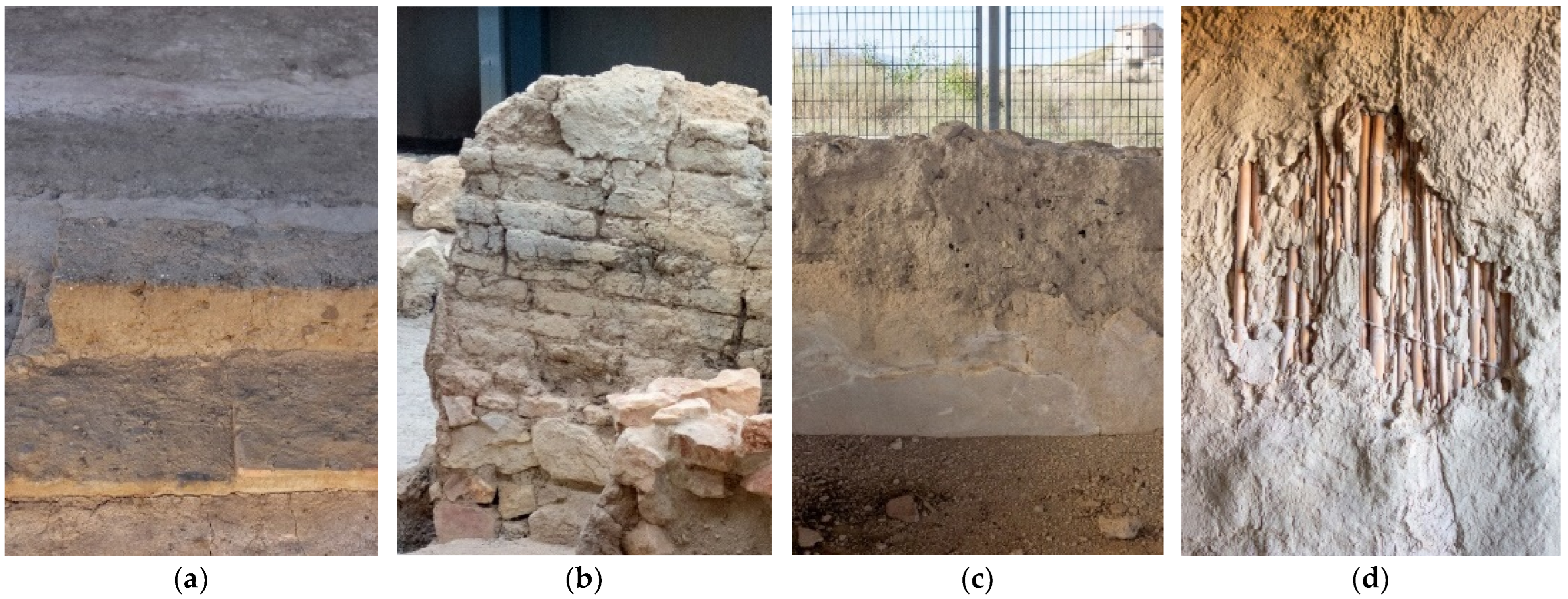
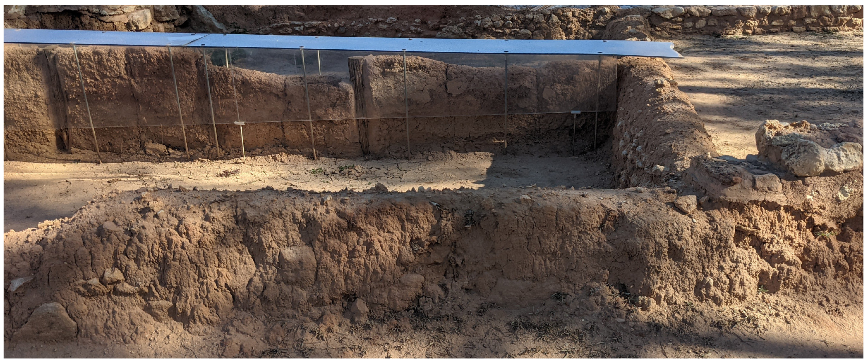
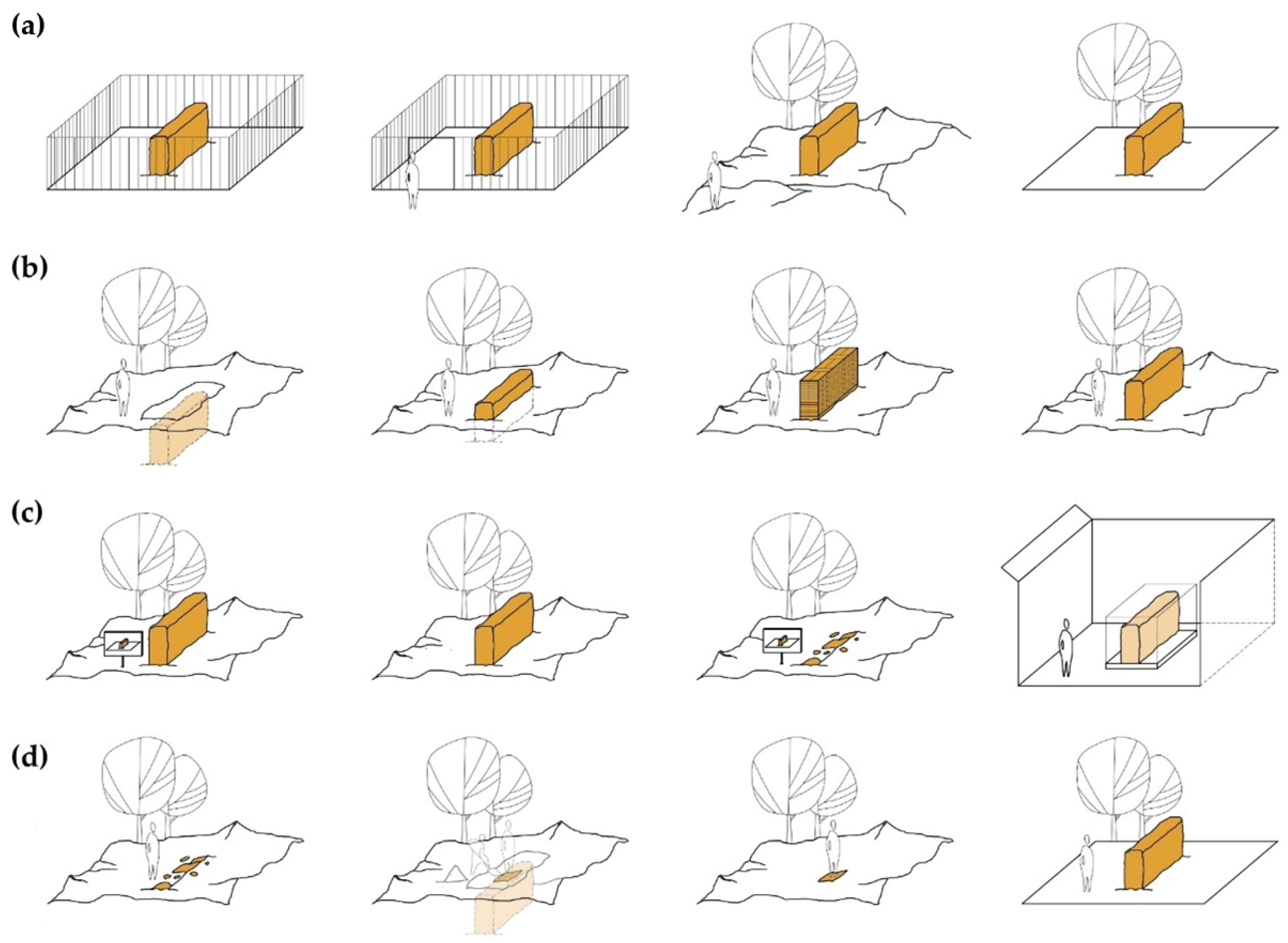
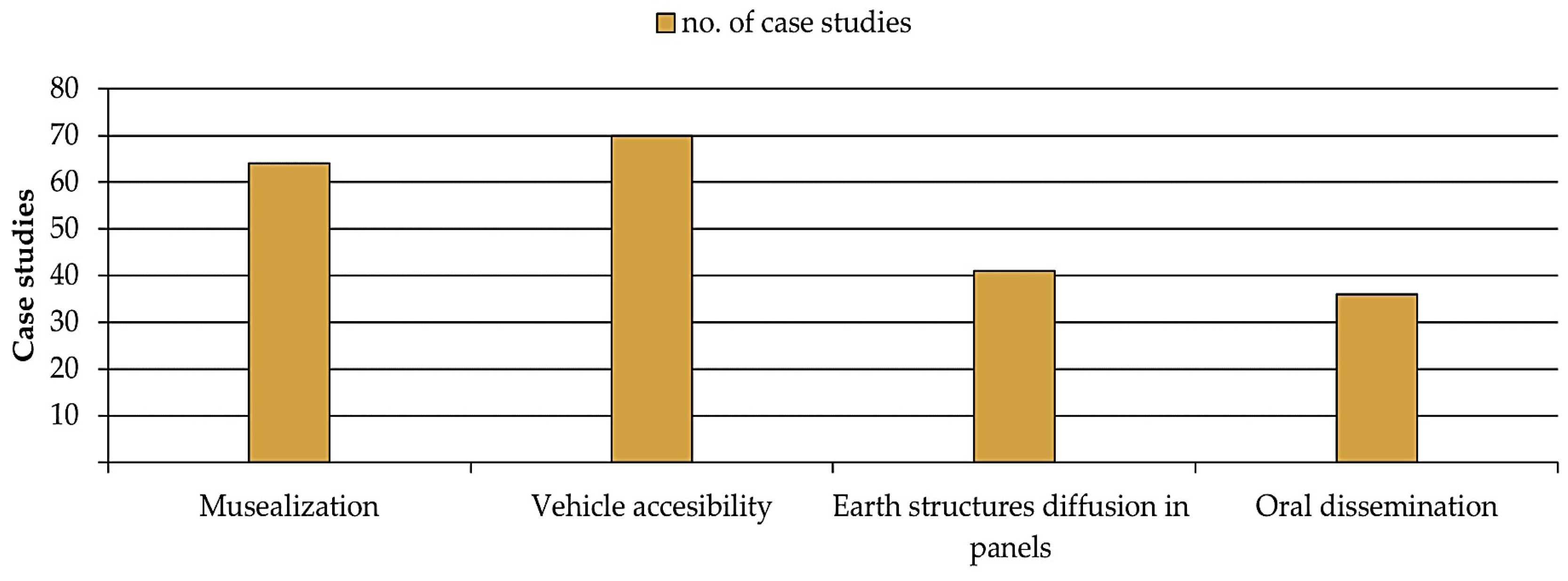
3.1.2. Musealization, Architectural Legibility, and Aesthetic Harmony

Another essential dimension of enhancement for tourist promotion is the transition from exposed remains to heritage sites adapted for visits. This subsequent cultural and exhibition use must reconcile preservation with research, encouraging promotion among the general public, showcasing as many typologies of musealization as there are museums, and requiring multidisciplinary collaboration to achieve optimum possible objectives. Broad distinctions can be established between in situ and ex situ musealization of archaeological sites.
In situ musealization involves the processes of incorporating materials, structures, and accessories for survival and visitation, ensuring physical preservation, adaptation of routes, and explanatory activities (Figure 9). As this research aims to highlight the human dimension, it is worth reflecting more deeply on the latter. The common use of signage and access paths introduces a physical limitation of informational space that affects content selection, potentially prioritizing other areas (historical, anthropological, etc.) over earthen construction (Figure 10a), without making up for the omitted information through QR codes or websites. This can result in information silence, further exacerbating the already diminished social recognition of earthen architecture by the general public, as seen in La Olmeda (Pedrosa de la Vega, Palencia), where reconstruction videos do not explore the material architectural characterization.
In this regard, 48% of the case studies selected have shown some form of on-site dissemination of these construction techniques, implying in turn that half of the sample does not present a complete knowledge transmission process, despite the rise in supporting elements experienced in musealization in recent years [43]. This occurs, for example, in oral communication, where audio guides do not always explore these fields, unlike guided tours, where these issues are more frequently described, providing the site offers such a service with trained technical staff (Figure 10b). In general terms, 42% of the cases engage in oral dissemination, a figure which increases to 63% for the sites that offer this type of service.
A separate matter is ex situ musealization, outside the original site, usually in interpretation centres or municipal libraries. Typically, this involves more or less movable property [31], which could be of interest if it corresponded to construction pieces, such as adobes extracted from the excavation, as seen in the museum at Cerro de la Cruz (Almedinilla, Córdoba) (Figure 10c). However, sometimes full-scale reconstructions of immovable property are carried out for the faithful reproduction of the architectural space, as seen in Cerro de las Cabezas (Valdepeñas, Ciudad Real) (Figure 10d) and Cerro de la Virgen (Orce, Granada).
In total, 75% of archaeological sites feature some form of musealization. The remaining 25% are either currently being excavated, closed due to various risks, or temporarily abandoned. These strategies complicate the transmission to the public, depending on how effectively the construction culture is conveyed to the untrained visitor. Conflicting characteristics such as durability versus traditional harmonious appearance, or protection, context, and landscape, often come into play here. When combined with the wide range of available intervention solutions in the market, these give rise to noticeable alterations in how knowledge of these techniques is transmitted to tourists. The heterogeneous nature of modern materials for protection and preservation plays a crucial role in this debate, as does simple maintenance, which is highly recommended for risk prevention in the physical object, concealing heterogeneous geographical construction under sacrificial protection or coatings.

3.1.3. Demographic Issue

Another factor of relevance when carrying out maintenance, adaptation, and tourist use activities smoothly is the availability of economic and human resources. In this regard, it is worth highlighting the demographic challenges faced by a substantial portion of Spain. These challenges give rise to scenarios of severe depopulation, potentially leading to the abandonment and deterioration of significant sites, stemming from responses that are less efficient, less immediate, and of lower quality. Likewise, the appeal to tourism could face greater challenges due to the lack of visibility in these depopulated areas, given the scarcity of complementary attractions to enhance their appeal.
Although the correlation of this scenario and actual conservation deficiencies has not been evaluated in the present analysis, it is nonetheless interesting to note the number of sites located in these municipalities as a further point for analysis in the social sphere.
In this context, the results concerning studies related to population density would indicate that 21% of cases are at risk. However, considering recent analyses incorporating other characteristics such as the physical environment, demographic trends, and predictions of population growth or reduction, this figure rose to 28% in 1991 and 34% in 2022, with 1% classified as very severe, 11% as severe, and 22% as intermediate (Figure 11).

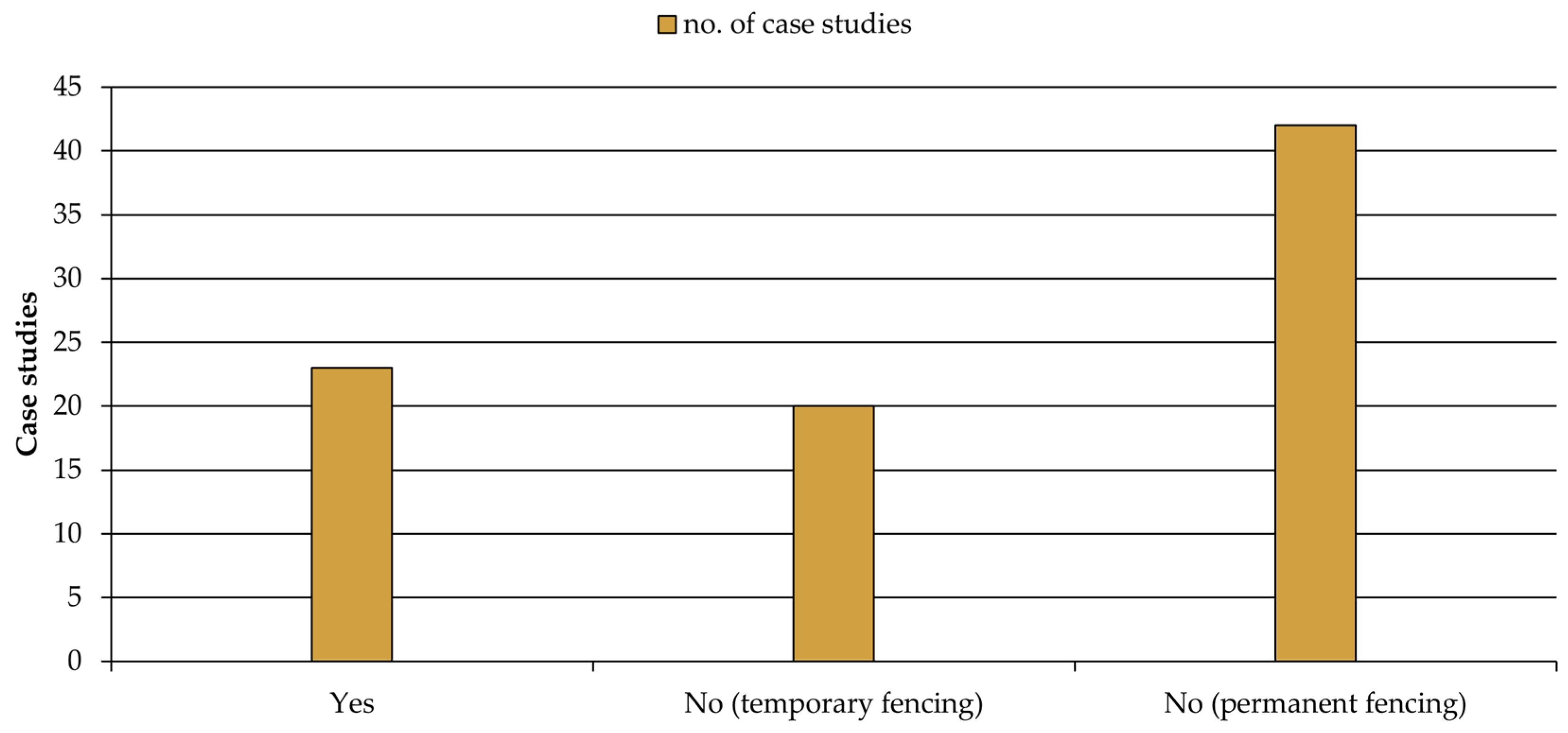
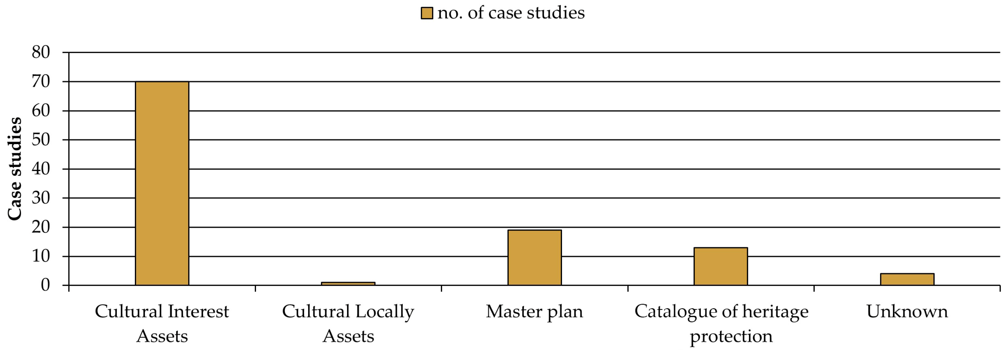
3.2. Legal and Urbanistic Protection

At the management level, legal protection provides the starting point for protecting and planning activities, with comprehensive knowledge that highlights the complexity of the site and its needs. Therefore, there may be a higher risk for sites lacking any protection, such as recognition as a Local Relevance Asset (BRL), Cultural Interest Asset (BIC), the development of Master Plans, or inclusion in Catalogues of heritage protection.
The sample shows results of 82% recognition as BIC and 1% as BRL (Figure 12). This would mean that almost a fifth of the sites exhibited a degree of legal lack of protection and the consequent higher risk of physical loss. Additionally, Master Plans have been accessed for 22% of the case studies, with some of them in various stages of development or final approval.

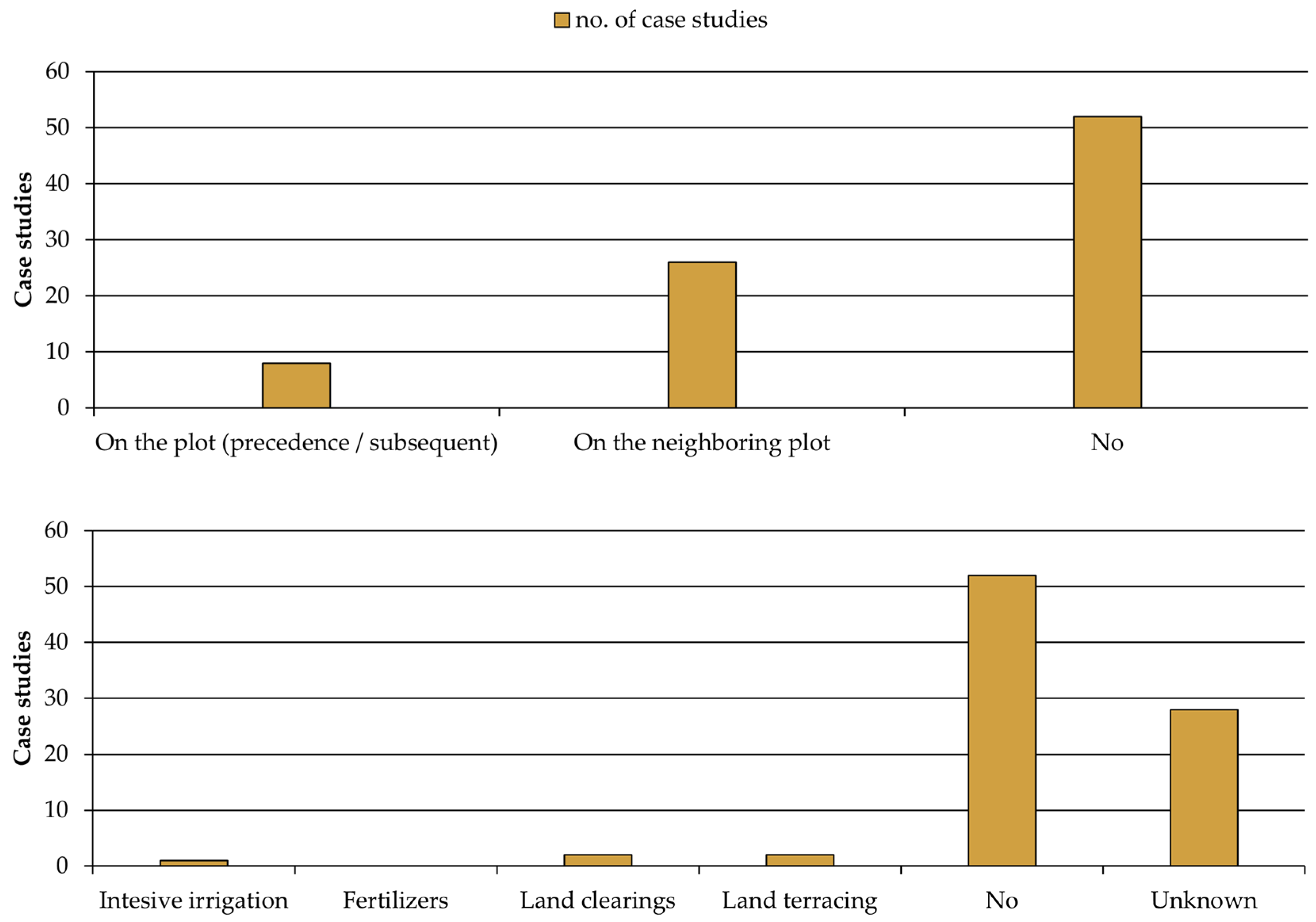
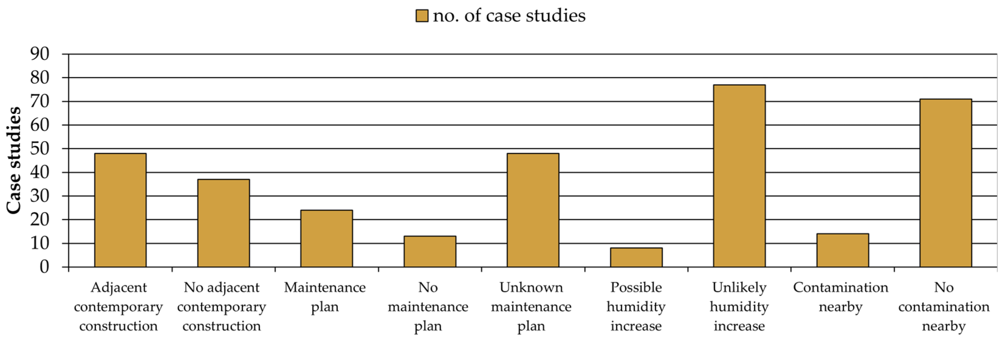
3.3. The Use of the Land

Human utilization of the land can take diverse forms and serve various purposes, with agricultural (Figure 13) and extractive (Figure 14) exploitation of materials emerging as the systems with the most influence on archaeological sites. Although the extractive exploitation of materials focused its destructive impact in the 20th century, erasing sensitive archaeological areas, while it is now inactive in all case studies, agriculture continues to present risks associated with ploughing, tillage, and harvesting (prior to excavation), as well as with indirect factors like soil compaction, irrigation, terrace construction, or compositional modification. These activities can reduce soil permeability, increase moisture (in the case of intensive irrigation in areas adjacent to archaeological sites), or introduce chemical pollutants that may alter groundwater. All of these factors require specific studies that consider soil characterization and, consequently, the real impact and extent based on the particular location in which they occur.
These scenarios have been observed in various archaeological sites under study, such as Cancho Roano (Zalamea de la Serena, Badajoz), where the impact of agriculture has led to the destruction of half of the adobe walls [44] (Figure 15a), which are currently reinterpreted through reconstructions. Another example is the Castellet de Banyoles (Tivissa, Tarragona), where the walls were reduced to a mere 30 cm in height [45] and have now been entirely lost. Other examples of reported intense agricultural activity could include the Castanheiro do Vento complex (Vila Nova de Foz Côa, Guarda), affecting the south, east, and west [46]; Casa del Mitreo (Mérida), in agricultural operation until the 20th century; or the Roman villa Piecordero I (Cascante, Navarra), with potential damage [47]. However, while the relationship between archaeological discoveries and farming activities is common, quantifying the actual extent of loss of structures is challenging once the remains are found. In general terms, up to 61% of the sample does not present a notable current risk due to factors derived from this issue, while 31% of structures are located in neighbouring or adjacent plots, and 9% show explicit agricultural use either before or after excavation (Figure 13).
Conversely, given the characteristics of the various soils, agricultural impact has been minimized in certain less suitable or fertile sites for the development of these activities, such as in Tossal del Moro [48]. Similarly, mountainous landscapes, like Turó d’en Roina/Can Taco (Montornès del Vallès), have also contributed to effective preservation of the remains, aided by the increased difficulty of access for curious visitors and enthusiasts.
The destruction caused by material extraction, now inactive, has potentially contributed to the widespread disappearance of structures, as observed in Puig de la Nau (Benicarló, Castellón) [33] (Figure 15d), El Oral (San Fulgencio, Alicante), and Cabezo Redondo (Villena, Alicante) [49] (Figure 15c), making 7% of total case studies; 93% of the samples did not experience these threats (Figure 14). It should also be noted how these earth-moving activities can introduce changes in topography that alter water runoff, disruptions in soil stratigraphy, or complications for tourist or scientific visits.

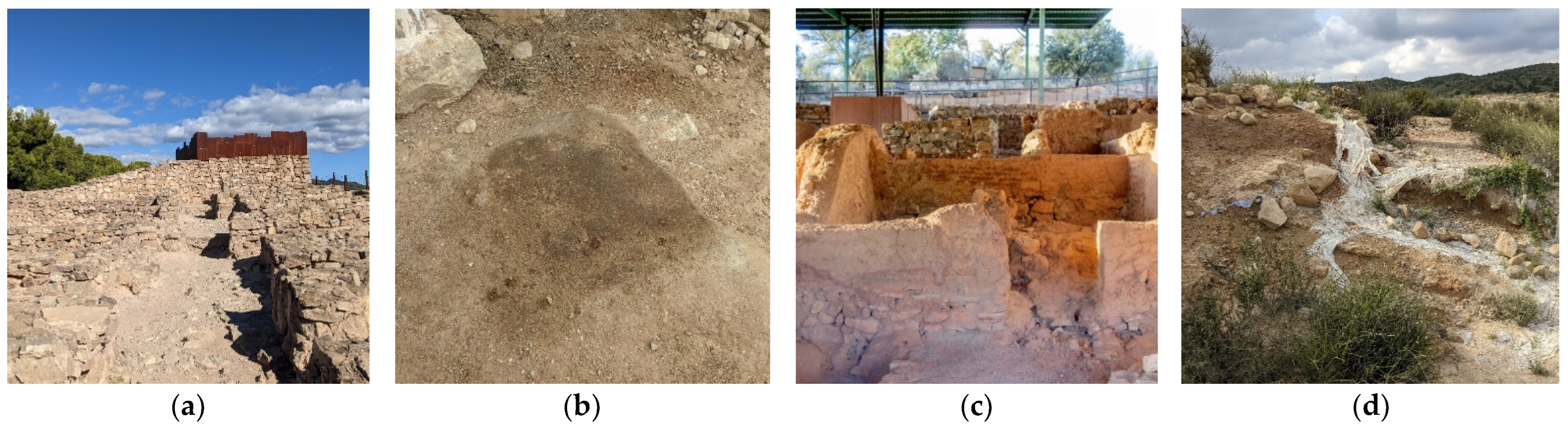
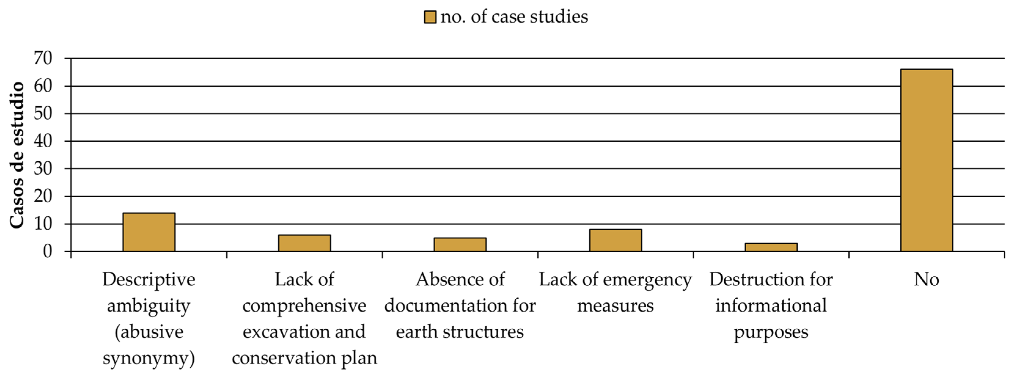
3.4. The Anthropic Damage

The excavation and enhancement of archaeological remains initiate new processes of degradation which were absent while these were underground, and active interaction with human visitors is one of the most prominent factors. The effects can be classified based on their origin, ranging from voluntary and involuntary vandalism (Figure 16) to the consequences of archaeological documentation actions, including various construction projects unearthing remains and, even in the worst cases, leading to their dismantling, burial, or destruction.
Vandalism plays an active role in the destruction of archaeological heritage and can be seen in numerous phases of its life cycle. This includes the indirect damage of looting and pillaging during burial or excavation stages, with a scope of destruction that is hard to determine, as reported in Coimbra del Barranco Ancho (Jumilla, Murcia), where the elevations of four rooms are affected [50], or those at La Lloma de Betxí (Paterna, Valencia) [29], where uncontrolled recurrence prompted their official excavation in 1984. Also notable is the dramatic or gradual destruction of earthen structures due to uncontrolled access by the public, as observed in Medina Siyasa (Cieza, Murcia), or through destruction following illegal trespass, as witnessed in the year 2017 at Los Villares/Kelin (Caudete de las Fuentes, Valencia). It is worth highlighting that, unlike in other types of heritage, the presence of pathologies such as graffiti is virtually non-existent in the examined sample.
However, these degradation effects can also indirectly be caused by the visiting public, either due to poorly planned circulations and routes, an excess of visitors, or other damage derived from poor awareness of value and preservation. This can take the form of walking over or carving on the structures. This damage can range from the complete destruction of earthen structures, as seen in Puntal dels Llops (Olocau, Valencia) [34] (Figure 17a) and La Casa Grande (Alcalá del Júcar, Albacete) [51], the loss of volume, as in the hearths of Puig de la Nau (Benicarló, Castellón) (Figure 17b), or the gradual reduction in thickness, as gradually experienced in the adobe structures of Cerro de la Cruz (Almedinilla, Córdoba) until their definitive enhancement (Figure 17c). Occasionally, the placement of structures in spaces with changes in elevation, such as the cob wall of Caramoro I (Elche, Alicante) [52], could cause future problems due to the lack of signage (Figure 17d). Visitor carving, on the other hand, while documented in various international sites, does not seem to be as much of a concern as vehicle access in the case studies documented.
Of the total sample, 32% of case studies are related to one of these phenomena, with 21% highlighting looting, 21% involving complete destruction, probably in collaboration with natural agents, and 6% associated with walking over.
The management of archaeological parks often has to face the challenges of the archaeological study and excavation process running parallel to tourism, introducing associated risks (Figure 18 and Figure 19). Much of the destruction in this regard occurred during the 20th century, due to the precarious nature of early excavations, often described as pseudo-clandestine surveys, where these techniques were mostly unknown and safety measures were non-existent.
Although to some extent these situations have become less frequent, it is still easy to observe destruction for informational purposes. These methodologies involve the voluntary dismantling of earthen structures whose lower stratum becomes inaccessible, aiming to complete the stratigraphic sequence of the ensemble and extract all available historical information. This usually comes at the expense of the disappearance of the original material, whose intrinsic characteristics cannot be recovered, as an inherent process to the ongoing destructive nature of archaeology, and one whose essentiality continues to be justified by professionals as a necessary compromise. These scenarios have been seen in sites such as Castellet de Banyoles (Tivissa, Barcelona), involving Iberian adobe floors and benches (Figure 20b), and in Cástulo (Linares, Jaén), where earthen paving has been removed, revealing Roman mosaics. This has also been observed in cases where preservation is impossible, such as in El Castillar (Mendavia, Navarra), taking advantage of the extraction process for thorough documentation [53].
While these factors are challenging to detect retrospectively, 78% of the selected cases do not exhibit this impact, and descriptive ambiguity is noted in 16% of these. The absence of emergency measures accounts for 9%, lack of comprehensive planning in the excavation and intervention process for 7%, absence of documentation in 6% of cases, and physical destruction or dismantling for informational purposes in 4% of the sample.
Another issue associated with human action, although not necessarily with tourism, is related to indirect impacts on the urban or built environment, as well as the execution of infrastructure. It is clear that a significant number of archaeological findings are directly associated with urban development initiatives, which, in favourable instances, document, safeguard, and bury the remnants, or alter their routes to minimize impact. In less favourable scenarios, these initiatives can lead to physical damage, dismantling, or outright destruction of archaeological sites.
In an urban context, some sites are affected by this issue. This can be seen in the kilns of El Arsenal (Elche, Alicante), affected by the proposed urban development plan for the area [54] or Tossa de les Basses (Alicante), at risk of destruction due to channelling of the ravine, expansion, or renovation of the railway (Figure 20c). Regarding infrastructure, there are various clear examples, such as the slight deviation of the A-4 motorway brought about by the discovery of the Cerro de las Cabezas (Valdepeñas, Ciudad Real); the impact of the A-60 on the Lancia kilns, protected and buried in 2012 [55]; the destruction of Sitjar Baix (Onda, Castellón) due to the CV-10; or the dismantling of the L’aumedina kiln (Tivissa, Tarragona), adobe by adobe [56]. In special cases, this impact has been mitigated to prevent destruction through relocation interventions to a museum, such as the Arrollo Villalta kiln (Bobadilla, Málaga) to the Antequera Museum [57]; or kiln 5 of the El Ruedo pottery complex (Almedinilla, Córdoba) [58].
Finally, a range of minor factors arising from activities and circumstances generated by human intervention that could worsen conservation have also been considered. Among these factors are the potential to increase ambient humidity due to excess visitors in confined and unventilated spaces, the absence of maintenance plans, or the existence of elevated levels of environmental pollution. In some cases, such as the presence of noise pollution due to proximity to roads with heavy traffic (evident in sites like Tos Pelat in Moncada, Valencia), the tourist experience may be worsened, although they do not play an active role in the physical preservation of archaeological remains.
From a statistical perspective, these are anecdotal observations; 91% do not have containment structures that would favour the emergence of microclimates, with the remaining 9% being equipped with adequate ventilation systems; 84% of cases are not located in areas affected by pollution (industrial zones, large cities); and 56% are in direct contact or adjacent to contemporary structures.

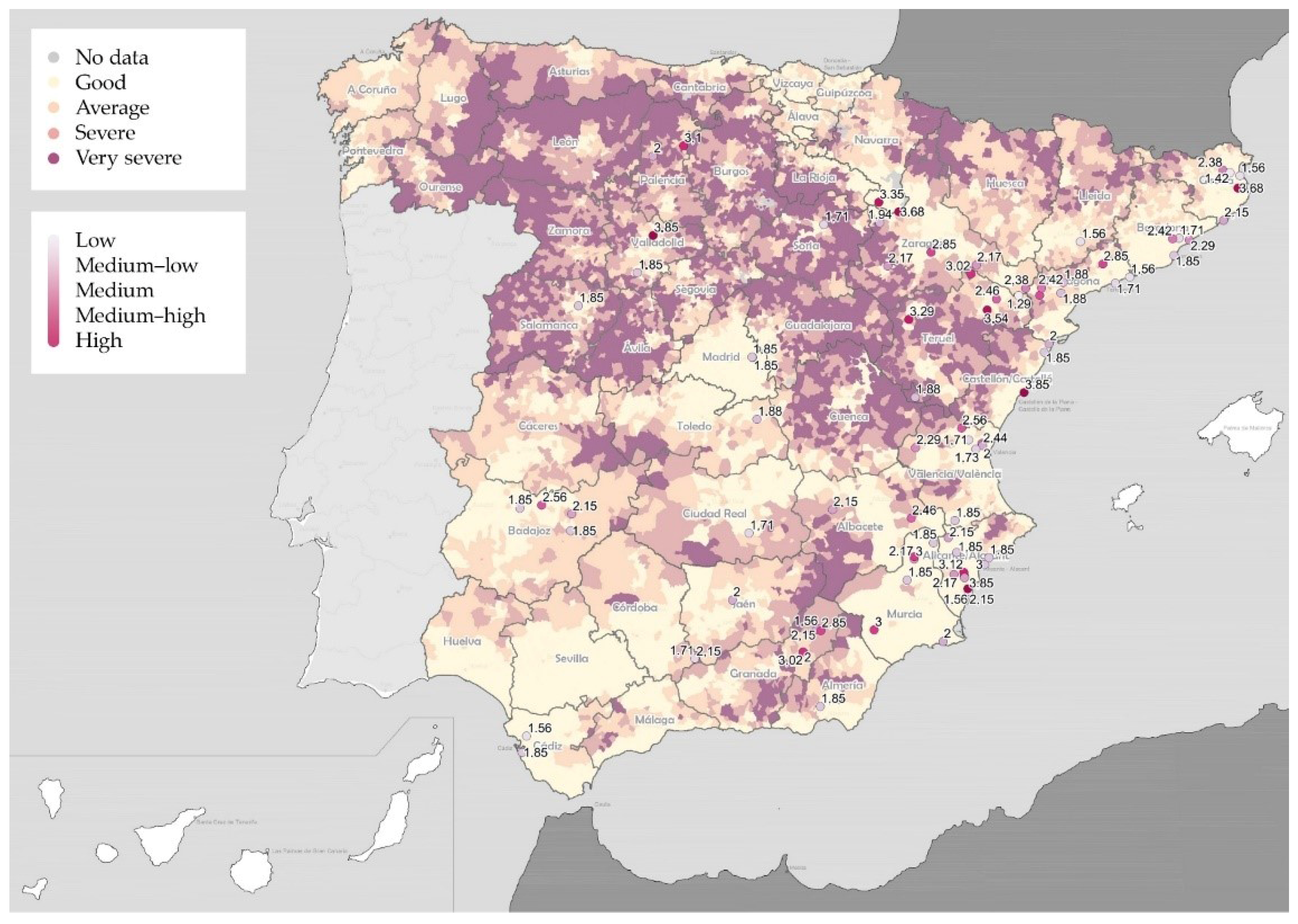
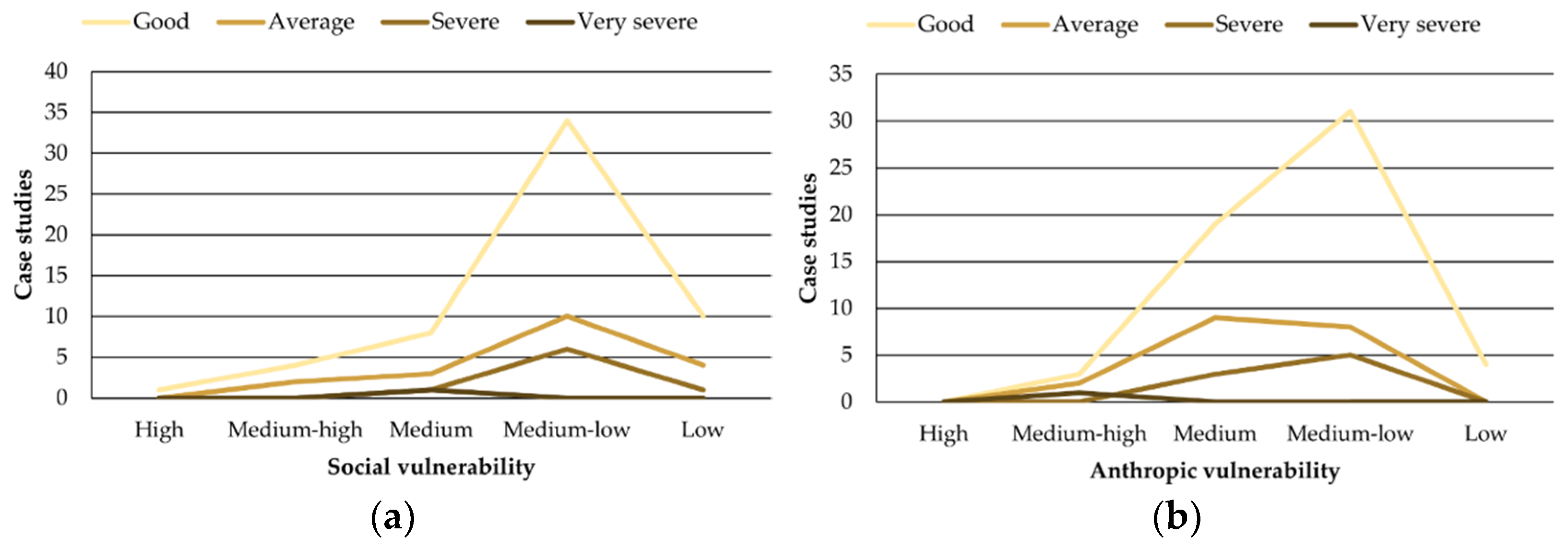
3.5. Quantitative Risk Assessment

The numerous trade-offs presented in the in situ conservation of archaeological remains in relation to tourism, scientific exploration, and land use demand intervention measures—as well as prevention and organization efforts—to minimize their occurrence and development. In this regard, assigning precise values according to the vulnerability assessment methodology described can establish a gradation of urgency and a review of the needs of such sites in the territorial landscape of Spain (Table 2).
These vulnerability indices, with a high degree of abstraction, have been overlaid in GIS environments using national information of human relevance, such as population density or demographic risk. This layer adds an additional dimension of specificity that lays the groundwork for studies reflecting on potential correlations between conservation and the degree of exploitation of heritage sites.
In terms of social risk, the vulnerability levels obtained show a distribution of 18% for the low category, 59% for the low–medium, 15% for the medium, 7% for the medium–high, and 1% for the high category. Noteworthy cases include El Arsenal (Elche, Alicante) for urbanistic vulnerability, the Mas de Moreno kilns (Foz-Calanda, Teruel), and Illa d’en Reixac (Ullastret, Girona) for difficulty of access, isolation, and lack of enhancement, respectively. In addition, the reburied sites of El Oral (San Fulgencio, Alicante), Alto de la Cruz (Cortes, Navarra) and Soto de Medinilla (Valladolid) stand out for their invisibility to the general public.
After data analysis, a higher demographic risk would be observed in municipalities such as La Oruña (Vera de Moncayo, Zaragoza), Lépida Celsa (Velilla de Ebro, Zaragoza), La Celadilla (Ademuz, Valencia), Cabezo de Alcalá (Azaila, Teruel), Cerro de la Virgen (Orce, Granada), Libisosa (Lezuza, Albacete), El Amarejo (Bonete, Albacete), Castellón Alto, and the necropolis of Tútugi (Galera, Granada). The case of La Oruña stands out as very severe, and El Amarejo, Tútugi, Castellón Alto, Lépida Celsa, and Cerro de la Virgen show a severe risk [42] (Figure 21).
This reveals a significant concurrence between human vulnerability and depopulation, especially in intermediate levels, with up to seven case studies showing medium vulnerability in municipalities with intermediate risk levels (Figure 22). However, a more in-depth study is required to determine a direct correlation between both factors, as this could be due to the broader spectrum in these vulnerability levels.
In terms of anthropic risk, the vulnerability levels obtained are slightly higher, with 5% for the low category; 52% for low–medium; 36% for medium; and 7% for medium–high. Particularly vulnerable cases stand out, including La Oruña, inserted in agricultural landscapes, the Roman villa Piecordero I (Cascante, Navarra), La Lloma de Betxí (Paterna, Valencia), Castellet de Banyoles and Cerro de las Cabezas (Figure 23).
In the data cross-referencing, a higher accumulation of case studies with elevated vulnerability levels is observed in municipalities with a population density of <75 inhabitants/km2, particularly in terms of social vulnerability, while a similar accumulation of risk is also present in densely populated cities with densities exceeding 1000 inhabitants/km2 (Figure 24). Although further study is needed to determine direct correlations between factors, similar to the demographic data analysis, this concentration in environments with smaller populations can cause greater real impact due to limited economic or human resources for dissemination, conservation, and tourist use.

4. Discussion

The qualitative reflection, statistical compilation, and quantitative evaluation lead to several noteworthy insights regarding the social aspect of tourist use, valorisation, legal protection, and associated threats. Overall, the level of vulnerability observed corresponds to a medium-low and medium value for the social domain and is slightly higher for the anthropic domain, with a predominance of medium indices (Figure 25).
Regarding this last point, it is worth noting that a quarter of the case studies cannot be visited, although those accessible generally allow visits for more than eight days a month or freely and permanently. In addition, a vast majority are musealized and legally protected through at least one available tool. In contrast, only half have provided information about earthen structures on their on-site informational signage, and approximately half lack comprehensive surveillance measures (or these are unknown).
The aspect of accessibility, positively oriented towards dissemination and tourist visits, is inversely valued regarding anthropic risk. This may have contributed to its overall higher vulnerability, exposing the remains to increased human interaction, potentially resulting in more walking over or degradation as visitors lean on or touch the upper sections of low structures, such as homes and walls, as well as pavements. In contrast, as the impact of carving is moderate or non-existent in the case of carving, it should be addressed through preventive social recognition but is not considered so urgent.
Regarding the remaining anthropic factors, in many cases there has been a drop in activity in the previous agriculture and quarrying, so that many of them are currently inactive. However, it is important to consider the presence of intensive irrigation adjacent to the conservation and tourist valorisation project, as water control in the area can be a relevant factor when proposing solutions.
Destruction due to looting, vandalism, and scientific factors should be reflected on. In this regard, it is vital to establish cross-disciplinary points shared by archaeology, architecture and conservation specialists, in order to unify their opposing perspectives, allowing them to meet demands with the means currently available. In keeping with this, and in cases where non-invasive technology is insufficient for documentation, it is advisable not to rule out proposals for selective excavations in agreed areas where extensive dismantling is not required. Equally, whenever possible, knowledge of specific spaces should be inferred or discarded based on the sequences of adjoining spaces with no earthen structures preserved. As this issue affects one in every fifteen enclaves of these characteristics in the Iberian Peninsula, an updated and thorough debate in contemporary society is required for international impact.

5. Conclusions

The domestic, productive and funerary archaeological heritage executed in earth in Spain is a valuable resource, found in limited amounts, which can lead to a vigorous promotion of tourism around its locations and surroundings (Figure 26). However, there are numerous vulnerability factors which can minimize the social scope and increase the physical loss of remains when the site is in operation.
The scope of anthropic influence generates problems of relative severity following both excavation and exposure, in combination with other natural risks. Invisibilisation is also an issue, as it can deny society the enjoyment of the knowledge contained. The conditions imposed for cultural use and dissemination in cases of states of partial collapse, which require strategies for preservation in the event of the general natural risks affecting heritage, inevitably have a bearing on the maintenance of the original setting and the excessive visual homogenization of the spectrum of construction techniques. The general lack of master plans highlights the heterogeneous interventions currently observed in the professional community, imposing confusions which can discourage tourist interest and facilitate erroneous associations of systems. The selection of content to be transmitted through traditional signage and new technologies prioritizes the historical aspect, while succinctly addressing that of construction, with a more informative than educational approach, and not always explicitly displaying precision in terms of the material component, thus prolonging its limited recognition. A compromised assessment encourages the recurrence of acts of vandalism, both voluntary and involuntary, giving rise to the need for increasingly invasive interventions linked to the remaining factors.
Designing interventions to address this issue requires consideration of the particular characteristics of each archaeological site, achievable through studies initiated via Master Plans and multidisciplinary observation involving various fields throughout the entire process. While issues such as vandalism or looting should be addressed through educational exercises, administrative actions can provide the necessary surveillance and legal protection. The current process for ascertaining recurrence and urgency can preventively locate focal points of interest, minimize threats which arise when excavating the original structures, and facilitate the safeguarding of the remains throughout their cultural life cycle.

Author Contributions

Conceptualization, S.M.-F., C.M., F.V.L.-M. and V.C.; methodology, S.M.-F., C.M. and F.V.L.-M.; software, S.M.-F.; validation, S.M.-F.; formal analysis, S.M.-F.; investigation, S.M.-F.; resources, S.M.-F., C.M., F.V.L.-M. and V.C.; data curation, S.M.-F.; writing—original draft preparation, S.M.-F.; writing—review and editing, S.M.-F., C.M., F.V.L.-M. and V.C.; visualization, S.M.-F.; supervision, C.M., F.V.L.-M. and V.C.; project administration, C.M. and F.V.L.-M.; funding acquisition, C.M. and F.V.L.-M. All authors have read and agreed to the published version of the manuscript.

Funding

This work is part of the research project “Risk-Terra: La arquitectura de tierra en la Península Ibérica: Estudio de los riesgos naturales, sociales y antrópicos y estrategias de intervención e incremento de la resiliencia” (Ref. RTI2018-095302-B-I00; main researchers: Camilla Mileto and Fernando Vegas), funded by the Spanish Ministry of Science, Innovation and University. This research has been developed within a doctoral thesis funded by the Spanish Ministry of Science, Innovation and University (Ref. PRE2019-089629).

Data Availability Statement

The original contributions presented in the study are included in the article, further inquiries can be directed to the corresponding author.

Acknowledgments

To the Ministry of Science and Innovation of Spain for funding the research that is part of the present study at the Research Centre for Architecture, Heritage, and Management for Sustainable Development (PEGASO) at the Polytechnic University of Valencia. Also, to the guides of the different archaeological sites for sharing their experiences and knowledge in the preservation and dissemination of each of them.

Conflicts of Interest

The authors declare no conflicts of interest. The funders had no role in the design of the study; in the collection, analyses, or interpretation of data; in the writing of the manuscript, or in the decision to publish the results.

References

  1. Guillaud, H. An Approach to the Evolution of Earthen Building Cultures in Orient and Mediterranean Regions. What Future for Such an Exceptional Legacy? Al-Rāfidān J. West. Asiat. Stud. 2003, 24, 1–28. [Google Scholar]
  2. Fidler, J. Terra 2000 Postprints: 8th International Conference on the Study and Conservation of Earthen Architecture, Torquay, Devon, UK, May 2000; Routledge: London, UK, 2002. [Google Scholar]
  3. Joffroy, T.; Guillaud, H.; Sadozaï, C. Terra Lyon 2016: Articles Sélectionnés Pour Publication En Ligne/Articles Selected for on-Line Publication/Artículos Seleccionados Para Publicación En Línea; Editions Craterre: Villefontaine, France, 2018. [Google Scholar]
  4. UNESCO World Heritage Centre. World Heritage Earthen Architecture Programme 2009/2017; UNESCO World Heritage Centre: Paris, France, 2008. [Google Scholar]
  5. Cooke, L. Conservation Approaches to Earthen Architecture in Archaeological Contexts; British Archaeological Reports; BAR Publishing: Oxford, UK, 2010. [Google Scholar]
  6. Pedelì, C.; Pulga, S. Conservation Practices on Archaeological Excavations: Principles and Methods; Getty Conservation Institute: Los Angeles, CA, USA, 2013. [Google Scholar]
  7. Bendakir, M. Les Vestiges de Mari: La Préservation d’une Architecture Millénaire; Editions de La Villette: Grenoble, France, 2009. [Google Scholar]
  8. Pastor Quiles, M. La Construcción Con Tierra En Arqueología. Teoría, Método, Técnicas y Aplicación; Publicaciones de la Universidad de Alicante: Sant Vicent del Raspeig, Spain, 2017. [Google Scholar]
  9. Belarte Franco, M.C. L’utilisation de La Brique Crue Dans La Péninsule Ibérique Durant La Protohistoire et La Période Romaine; de Chazelles, C.-A., Klein, A., Pousthomis, N., Eds.; Editions de l’Espérou: Montpellier, France, 2011. [Google Scholar]
  10. Beltrán Lloris, M. La Casa Hispanorromana. Modelos. Bolskam 2003, 20, 13–63. [Google Scholar]
  11. Bruno, P. Arquitecturas de Terra nos Espaços Domésticos Pré-Históricos do Sul de Portugal. Sítios, Estructuras, Tecnologías e Materiais, Universidade de Lisboa. Available online: https://repositorio.ul.pt/handle/10451/3475 (accessed on 14 January 2024).
  12. Olaio, A. From Earth to Structure: New Insights on the Iron Age Domestic Architecture from Quinta Do Almaraz (Almada, Portugal). In Proceedings of the ARAR Arqueología & Arquitectura. La Arquitectura de Tierra en el Mediterráneo Antiguo: Perspectivas, Estrategias y Metodologías (Guareña-Badajoz, 21–24 de febrero de 2024), Guareña, Spain, 21–24 February 2024. [Google Scholar]
  13. Manzano-Fernández, S.; Mileto, C.; Vegas, F.; Cristini, V. Examination of Earthen Construction in Archaeological Sites of the Iberian Peninsula for Risk Analysis. In Vernacular Heritage: Culture, People and Sustainability: Heritage 2022 International Conference, Valencia, Spain, 15–17 September 2022; Mileto, C., Vegas, F., Cristini, V., García-Soriano, L., Eds.; Universitat Politècnica de València: Valencia, Spain, 2022; pp. 401–408. [Google Scholar] [CrossRef]
  14. De Chazelles, C.-A. Les Constructions En Terre Crue d’Empúries a l’époque Romaine. Cypsela 1990, VIII, 101–118. [Google Scholar]
  15. Mileto, C.; Vegas, F.; Cristini, V.; García-Soriano, L. Initial Assessment of Multi-Risk Social Vulnerability for Iberian Earthen Traditional Architecture. Procedia Struct. Integr. 2020, 29, 34–39. [Google Scholar] [CrossRef]
  16. Reeder-Myers, L.A. Cultural Heritage at Risk in the Twenty-First Century: A Vulnerability Assessment of Coastal Archaeological Sites in the United States. J. Isl. Coast. Archaeol. 2015, 10, 436–445. [Google Scholar] [CrossRef]
  17. Taçon, P.S.C.; Baker, S. New and Emerging Challenges to Heritage and Well-Being: A Critical Review. Heritage 2019, 2, 1300–1315. [Google Scholar] [CrossRef]
  18. AA.VV. Las Excavaciones Arqueológicas y Sus Problemas. Legislación; Institución Fernando el Católico: Zaragoza, Spain, 1980. [Google Scholar]
  19. Nakhaei Ashtari, M.; Correia, M. Assessment of Vulnerability and Site Adaptive Capacity to the Risk of Climate Change: The Case of Tchogha Zanbil World Heritage Earthen Site in Iran. J. Cult. Herit. Manag. Sustain. Dev. 2022, 12, 107–125. [Google Scholar] [CrossRef]
  20. Daly, C. A Framework for Assessing the Vulnerability of Archaeological Sites to Climate Change: Theory, Development, and Application. Conserv. Manag. Archaeol. Sites 2014, 16, 268–282. [Google Scholar] [CrossRef]
  21. García, B.M. Resilient Cultural Heritage for a Future of Climate Change. J. Int. Aff. 2020, 73, 101–120. [Google Scholar]
  22. Bertolín, C.; Camuffo, D. Deliverable 5.2 Climate Change Impacts Movable and Immovable Cultural Heritage throughout Europe. Damage risk assessment, economic impact and mitigation strategies for sustainable preservation of cultural heritage in the times of climate Change. In Climate for Culture; The European Climate Adaptation Platform Climate-ADAPT: Washington, DC, USA, 2014. [Google Scholar]
  23. Arias Vilas, F. Sitios Musealizados y Museos de Sitio: Notas Sobre Dos Modos de Utilización Del Patrimonio Arqueológico. Museo 1999, 4, 39–57. [Google Scholar]
  24. Correia, M. Evaluation Criteria for Earthen Archaeological Sites. In Conservation des Architectures de Terre sur les Sites Archéologiques. Nouvelles Pratiques et Perspectives; Gandreau, D., Sadozaï, C., Eds.; Éditions CRAterre: Grenoble, France, 2015; pp. 54–58. [Google Scholar]
  25. Manzano-Fernández, S. Arquitectura de Tierra En Yacimientos Arqueológicos de La Península Ibérica: Estudio de Riesgos Naturales, Sociales, Antrópicos y Estrategias de Intervención, Universitat Politècnica de València. 2023. Available online: https://riunet.upv.es/handle/10251/197994 (accessed on 24 January 2024).
  26. Juncà Ubierna, J.A.; Amigo Alvaro, R.; Ruiz Díaz, F.J.; García García-Castro, C.; Zarza Alejo, R. Accesibilidad Universal Al Patrimonio Cultural. Fundamentos, Criterios y Pautas; Ministerio de Sanidad, Política social e Igualdad: Madrid, Spain, 2011.
  27. de Guichen, G. Plan de Conservación Preventiva de La Cueva de Altamira; Instituto del Patrimonio Cultural de España: Madrid, Spain, 2014. [Google Scholar]
  28. Instituto del Patrimonio Cultural Español. La Conservación y Restauración del Patrimonio Cultural Exige un Conocimiento Profundo y Riguroso de Los Bienes Que lo Integran: Su Historia, Significados o Valores, Las Circunstancias, Procesos y Contextos de su Creación y Evolución. Available online: https://ipce.cultura.gob.es/investigacion/conservacion-bienes-culturales/documentacion-estudios.html (accessed on 9 April 2024).
  29. De Pedro Michó, M.J.; Fumanal García, M.P.; Ferrer García, C.; Jover Maestre, F.J.; Lopez Padilla, J.A.; Grau Almero, E.; Pérez-Jordà, G.; Sarrión Montañana, I. La Lloma de Betxí (Paterna, Valencia), Un Poblado de La Edad Del Bronce; Diputación Provincial de Valencia, Servicio de Investigación Prehistórica: Valencia, Spain, 1998. [Google Scholar]
  30. Melucco Vaccaro, A. La Particularidad Del Problema Arqueológico. In La Carta de Riesgo: Una Experiencia Italiana Para la Valoración Global de los FACTORES de Degradación del Patrimonio Monumental; Istituto Superiore per la Conservazione ed il Restauro, Instituto andaluz del patrimonio Histórico, Eds.; Junta de Andalucía, Instituto Andaluz del Patrimonio Histórico: Sevilla, Spain, 1992; pp. 18–21. [Google Scholar]
  31. Lasheras Corruchaga, J.A.; Hernández Prieto, M.Á. Explicar o Contar. La Selección Temática Del Discurso Histórico En La Musealización. In III Congreso Internacional Sobre Musealización de Yacimientos Arqueológicos. De la Excavación al Público. Procesos de Decisión y Creación de Nuevos Recursos; de Francia Gómez, C., Erice Lacabe, R., Eds.; Ayuntamiento de Zaragoza, Área de Cultura y Turismo, Servicio de Cultura: Diputación Provincial de Zaragoza; Institución ‘Fernando el Católico’: Zaragoza, Spain, 2005; pp. 129–136. [Google Scholar]
  32. Gandreau, D. Patrimoine Archéologique En Terre et Développement Local. Enjeux Interdisciplinaires et Perspectives de Formation, Université Grenoble Alpes, ENSAG. 2017. Available online: https://theses.hal.science/tel-01734984 (accessed on 11 December 2023).
  33. Gusi Jener, F.; Oliver Foix, A.; Gómez Bellard, F.; Arenal, I.; Pérez-Pérez, A.; Valdés, L.; Cubero, C.; López de Roma, M.T.; Burjachs, F.; Castaños Ugarte, P.; et al. El Puig de La Nau: Un Hábitat Fortificado Ibérico En El Ámbito Mediterráneo Peninsular; Diputació de Castelló: Castellón de la Plana, Spain, 1995. [Google Scholar]
  34. Bonet Rosado, H.; Mata Parreño, C. El Puntal Dels Llops: Un Fortín Edetano; Diputación Provincial de Valencia, Servicio de Investigación Prehistórica: Valencia, Spain, 2002. [Google Scholar]
  35. Leopold, L.B.; Clarke, F.E.; Hanshaw, B.B.; Balsey, J.R. Procedure for Evaluating Environmental Impact; US Department of the Interior: Washington, DC, USA, 1971; Volume 2. [CrossRef]
  36. Cappai, M.; Pia, G. Un modelo Fuzzy para el estudio de la cinética de degradación en sitios arqueológicos. In Proceedings of the ARAR Arqueología & Arquitectura. La Arquitectura de Tierra en el Mediterráneo Antiguo: Perspectivas, Estrategias y Metodologías (Guareña-Badajoz, 21–24 de Febrero de 2024), Guareña, Spain, 21–24 February 2024. [Google Scholar]
  37. Forino, G.; MacKee, J.; von Meding, J. A Proposed Assessment Index for Climate Change-Related Risk for Cultural Heritage Protection in Newcastle (Australia). Int. J. Disaster Risk Reduct. 2016, 19, 235–248. [Google Scholar] [CrossRef]
  38. Verd, J. Recursos Para Las CTMA: La Matriz de Leopold, Un Instrumento Para Analizar Noticias de Prensa de Temática Ambiental. Enseñanza Cienc. Tierra 2000, 8, 239–246. [Google Scholar]
  39. AA.VV. Atlas Climático Ibérico: Temperatura Del Aire y Precipitación (1971–2000); Agencia Estatal de Meteorología, Ministerio de Medio Ambiente y Medio Rural y Marino, Instituto de Meteorología de Portugal: Lisbon, Portugal, 2011. [CrossRef]
  40. AA.VV. España En Mapas. Una Síntesis Geográfica; Ministerio de Fomento: Madrid, Spain, 2019. [CrossRef]
  41. AA.VV. Directrices Generales de la Estrategia Nacional Frente al Reto Demográfico; Ministerio para la Transición Ecológica y el Reto Demográfico: Madrid, Spain, 2023.
  42. Zúñiga-Antón, M.; Guillén, J.; Caudevilla, M.; y Bentué-Martínez, C. Mapa 174. Zonificación de los Municipios Españoles Sujetos a Desventajas Demográficas Graves y Permanentes. StoryMap. Available online: https://storymaps.arcgis.com/stories/9dd9b6e20cad403c95e87d4cc493c8fb (accessed on 26 January 2024).
  43. Beltrán de Heredia Bercero, J.; Sánchez Montes, A.L.; Rascón Marqués, S. Pasado, Presente y Futuro de La Musealización de Yacimientos En España. VI Congr. Int. Musealización Yacim. Patrim. 2010, 1, 139–159. [Google Scholar]
  44. Maluquer de Motes, J. El Santuario Protohistórico de Zalamea de La Serena, Badajoz; Consejo Superior de Investigaciones Científicas, Universidad de Barcelona: Barcelona, Spain, 1981. [Google Scholar]
  45. Asensio Vilaró, D.; Sanmartí Grego, J.; Jornet Niella, R.; Miró Alaix, M.T. L’urbanisme i l’arquitectura Domèstica de La Ciutat Ibèrica Del Casteller de Banyoles (Tivissa, Ribera d’Ebre). In Iberos del Ebro. Actas del II Congreso Internacional (Alcañiz-Tivissa, 16–19 de Noviembre de 2011); Belarte Franco, M.C., Benavente Serrano, J.A., Fatás Fernández, L., Diloli Fons, J., Moret, P., Noguera Guillén, J., Eds.; Institut Català d’Arqueologia Clàssica (ICAC): Tarragona, Spain, 2012; pp. 173–193. [Google Scholar]
  46. Oliveira Jorge, V. Castanheiro Do Vento, Uma Ruína de Arquitetura de Terra (“Colina Monumentalizada”) Pré-Histórica Do Norte de Portugal. In SOS-Tierra: Restauración y Rehabilitación de la Arquitectura Tradicional de Tierra en la Península Ibérica; López-Manzanares, F.V., Mileto, C., Eds.; manuscript in preparation, submitted.
  47. Gómara Miramón, M.; Serrano Arnáez, B.; Bonilla Santander, Ó. Un Torcularium de Los Siglos I a.C.-I d.C. Del Yacimiento Romano Piecordero i (Cascante, Navarra). In Estudis sobre ceràmica i arqueologia de l’arquitectura. Homenatge al Dr. Alberto López Mullor; Aquilué Abadías, J., Beltrán de Heredia, J., Caixal Mata, A., Fierro Macià, X., Kirchner, H., Eds.; Diputación Provincial de Barcelona: Barcelona, Spain, 2020; pp. 417–425. [Google Scholar]
  48. Arteaga Matute, O.; Sanmartí Grego, E.; Padró Parcerisa, J. El Poblado Ibérico Del Tossal Del Moro de Pinyeres (Batea, Terra Alta, Tarragona); Institut de Prehistòria i Arqueología: Santander, Spain, 1990. [Google Scholar]
  49. Hernández Pérez, M.S.; García Atiénzar, G.; Barciela González, V. Cabezo Redondo (Villena, Alicante); Universidad de Alicante: San Vicente del Raspeig, Spain, 2019. [Google Scholar]
  50. García Cano, J.M.; Hernández Carrión, E.; Page del Pozo, V. Excavación de Urgencia En El Conjunto Arqueológico de Coimbra Del Barranco Ancho (Jumilla-Murcia) 1995. In Séptimas Jornadas de Arqueología Regional; Lechuga Galindo, M., Sánchez González, M.B., Eds.; Editora Regional de Murcia: Murcia, Spain, 2002; pp. 222–226. [Google Scholar]
  51. Broncano Rodríguez, S.; Coll Conesa, J. Horno de Cerámico Ibérico de La Casa Grande, Alcalá de Júcar (Albacete). Not. Arqueol. Hispánico 1988, 30, 187–228. [Google Scholar]
  52. Pastor Quiles, M.; Jover Maestre, F.J.; Martínez Monleón, S.; López Padilla, J.A. La Construcción Mediante Amasado de Barro En Forma de Bolas de Caramoro I (Elche, Alicante): Identificación de Una Nueva Técnica Constructiva Con Tierra En Un Asentamiento Argárico. Cuad. Prehist. Arqueol. Univ. Autónoma Madr. 2018, 1, 81–99. [Google Scholar] [CrossRef]
  53. Fonseca de la Torre, H.J.; Arróniz Pamplona, L.; Calvo Hernández, C.; Cañada Sirvent, L.; Meana Medio, L.; Bayer Rodríguez, X.; Pérez Legido, D. The Problematic Conservation of Adobe Walls in the Open-Air Site of El Castillar (Mendavia, Navarre, Spain). In Earthen Construction Technology: Proceedings of the XVIII UISPP World Congress, Paris, France, 4–9 June 2018; Daneels, A., Torras Freixa, M., Eds.; Achaeopress: Oxford, UK, 2021; pp. 109–117. [Google Scholar]
  54. Serrano, P. Cómo Se Ha Llegado Al Desaguisado de El Arsenal de Elche: Cronología de Otro Conflicto Urbanístico. Elche Plaza. 5 February 2021. Available online: https://alicanteplaza.es/como-se-ha-llegado-al-desaguisado-urbanistico-de-el-arsenal-de-elche-cronologia-de-otro-conflicto-urbanistico (accessed on 14 April 2023).
  55. Gustavo López, D. Sos Lancia (3) ¿También Serán Destruidos Los Hornos de Lancia? ProMonumenta: Asociación de Amigos del Patrimonio Cultural de León. 5 June 2017. Available online: http://promonumenta.com/sos-lancia-3-tambien-seran-destruidos-los-hornos-de-lancia (accessed on 21 March 2023).
  56. Pérez Suñé, J.M.; Rams Folch, P. Memòria. Desmuntatge de Les Estructures Arqueològiques Del Jaciment de l’Aumedina Situades Al PK 20+500 de Ka Carretera C-44; Generalitat de Catalunya: Barcelona, Spain, 2010. Available online: http://hdl.handle.net/10687/425594 (accessed on 21 June 2022).
  57. Santos Fernández, J.L. Adif Traslada al Museo de Antequera un Horno Romano Hallado Durante la Ejecución de las Obras de alta Velocidad. Terrae Antiqvae. 7 May 2012. Available online: https://terraeantiqvae.com/m/blogpost?id=2043782%3ABlogPost%3A205746 (accessed on 5 May 2023).
  58. Muñiz Jaén, I. Seguimiento Arqueológico En La Villa Romana de ‘El Ruedo’ (Almedinilla-Córdoba) II. Anu. Arqueol. Andal. 1998 2001, 3, 215–223. [Google Scholar]
Figure 1. Earthen architecture families identified in the study area: (a) Cob wall at the archaeological site of the Roman villa La Olmeda (Pedrosa de la Vega, Palencia); (b) Adobe wall with alternating courses at the Roman domus in sector 18 of Libisosa (Lezuza, Albacete); (c) Rammed earth and plaster wall in the Mezquita del Cortijo del Centeno (Lorca, Murcia); (d) Modern reconstruction of a mixed wall with woven reeds at Castellón Alto (Galera, Granada).
Heritage 07 00106 g001
Figure 2. Earthen structures preserved and protected in the archaeological site of La Celadilla (Ademuz, Valencia).
Heritage 07 00106 g002
Figure 3. Distribution of total and selected case studies for the analysis of human vulnerability in the Iberian Peninsula, characterized by the presence of earthen architectural structures.
Heritage 07 00106 g003
Figure 4. Schematic examples of analysed features: (a) Restricted access, limited, obstructed, or completely free; (b) Limited exposure due to burial, partially visible, visible with modern materials or original materials; (c) Visible with information, visible without information, through signage, or showcased in a museum; (d) Destruction, looting, walking over or without vandalism.
Heritage 07 00106 g004
Figure 5. Examples of access and visits in different archaeological sites: (a) Restricted access, lack of a road and musealization efforts at El Oral (San Fulgencio, Alicante); (b) Full-time open access through rural roads in Tossal del Moro (Pinyeres, Tarragona); (c) Roadside parking with a pedestrian path to Puntal dels Llops (Olocau, Valencia); (d) Vehicle parking adjacent to the site in Los Millares (Santa Fe de Mondújar, Almería).
Heritage 07 00106 g005
Figure 6. Access: list of case studies and availability for tourist visits based on their temporary or permanent perimeter restriction.
Heritage 07 00106 g006
Figure 7. Opening days: connection between case studies and tourist visit options.
Heritage 07 00106 g007
Figure 8. Surveillance: connection between case studies and their surveillance systems.
Heritage 07 00106 g008
Figure 9. Social enhancement factors: study cases and availability of tourist facilities.
Heritage 07 00106 g009
Figure 10. Examples of musealization and dissemination in different archaeological sites: (a) Selection of construction content excluding earthen techniques at the Roman villa of La Olmeda (Pedrosa de la Vega, Palencia); (b) Guided tours with a focus on adobe construction at Tossal del Moro (Pinyeres, Tarragona); (c) Exhibition of movable assets (adobes) extracted from the excavation at the museum of Cerro de la Cruz (Almedinilla, Córdoba); (d) Ex situ reconstruction of an earthen dwelling at the interpretation centre of the Cerro de las Cabezas (Valdepeñas, Ciudad Real).
Heritage 07 00106 g010
Figure 11. Demographic risk: evolution of depopulation risk in municipalities with tourist offerings of archaeological sites with earthen architecture.
Heritage 07 00106 g011
Figure 12. Legal protection: variability of tools identified in the different case studies.
Heritage 07 00106 g012
Figure 13. Agricultural activity: recurring scenarios affected by agricultural activity and type of activity conducted.
Heritage 07 00106 g013
Figure 14. Extractive activity: variability in material extraction activity in the archaeological sites of the sample.
Heritage 07 00106 g014
Figure 15. Examples of events and threats regarding land use: (a) In the foreground, reconstructed adobes after loss caused by agricultural activities. In the background, original structures unaffected by these, at Cancho Roano (Zalamea de la Serena, Badajoz); (b) Agricultural use near the archaeological site of Alquería de Bofilla (Bétera, Valencia); (c) Loss of structures due to gypsum quarrying at Cabezo Redondo (Villena, Alicante); (d) Loss of structures due to stone quarrying at Puig de la Nau (Benicarló, Castellón).
Heritage 07 00106 g015
Figure 16. Anthropic damages: recurrence of conservation threats of a human nature after tourist use and enhancement.
Heritage 07 00106 g016
Figure 17. Examples of events and effects related to anthropic damage: (a) Anthropogenic integral destruction of adobe structures at Puntal dels Llops (Olocau, Valencia); (b) Volume loss due to trampling in the hearth at Puig de la Nau (Benicarló, Castellón); (c) Reduction in height and thickness in adobe structures at Cerro de la Cruz (Almedinilla, Córdoba), currently restored; (d) Potential walking over due to elevation changes at Caramoro I (Elche, Alicante).
Heritage 07 00106 g017
Figure 18. Anthropic excavation or documentation factors: recurrence of conservation threats of a human nature due to excavation activity and documentation of archaeological remains.
Heritage 07 00106 g018
Figure 19. Other anthropic factors: recurrence of other human-related issues in archaeological sites in Spain.
Heritage 07 00106 g019
Figure 20. Examples of the impact of other anthropogenic factors: (a) Loss of structures due to the absence of relief measures, due to the delayed acquisition of remains at Illeta dels Banyets (El Campello, Alicante); (b) Dismantling of pavement and adobe benches for documentary reasons to complete the archaeological sequence at Castellet de Banyoles (Tivissa, Tarragona); (c) Abandonment and risk of urbanization over kilns at Tossal de les Basses (Alicante); (d) Ventilation of structures in the semi-basement of the container building of Cerro de la Mota (Medina del Campo, Valladolid).
Heritage 07 00106 g020
Figure 21. Data cross-referencing in case studies from Spain: social vulnerability indices (low–high) and demographic risk (good–very severe).
Heritage 07 00106 g021
Figure 22. Data cross-referencing in case studies from Spain: demographic risk (good, average, severe, very severe) compared to results of social vulnerability (a) and anthropic vulnerability (b) (low, medium-low, medium, medium-high, high) of the archaeological sites.
Heritage 07 00106 g022
Figure 23. Data cross-referencing in case studies from Spain: anthropic vulnerability indices (low–high) and population density (from <5 inhabitants/km2 to >1000 inhabitants/km2).
Heritage 07 00106 g023
Figure 24. Data cross-referencing in case studies from Spain: municipal density <5 to >1000 inhab/km2 compared to results of social vulnerability (a) and anthropic vulnerability (b) (low, medium-low, medium, medium high, high) of the archaeological sites.
Heritage 07 00106 g024
Figure 25. Levels of vulnerability for the social and anthropic aspects.
Heritage 07 00106 g025
Figure 26. Enhancement and protection through permanent covers in La Mata (Campanario, Badajoz), as a focal point in municipal tourism promotion.
Heritage 07 00106 g026
Table 1. Response (regular) and importance (bold) values assigned to human vulnerability factors identified. The response values are associated with a scale from 1 to 5, while the importance values are determined between 0 and 1.
Risk
Factor
Social
Value
Anthropic ValueRisk
Factor
Social
Value
Anthropic Value
Access1.00.7Vandalism-0.9
   Not accessible51   Not present-1
   Limited access33   Walked upon/Carving-3
   Open access (obstacles)25   Looting-4
   Open access15   Destruction-5
Exposure0.70.7Agricultural activity-0.6
   Buried51   Not present-1
   Reburied42   Previously-3
   Partially visible33   In adjacent plot-5
   Visible (covered)35Extractive activity-1.0
   Visible (non-original)35   Not present-1
   Visible15   Present -5
Legal protection1.0-Maintenance plan-0.9
   Not present5-   Not present-5
   Present1-   Present-1
Enhancement interventions0.7-Pollution-0.2
   Not present5-   Not present-1
   In a museum3-   Present-5
   On panels3-Aesthetic harmony0.7-
   Preserved without panels2-   Completely covered4-
   Preserved with panels1-   Modern reconstruction3-
Surveillance0.7-   Encapsulation3-
   Not present5-   Capping2-
   Occasional3-   Traditional reconstruction2-
   Exhaustive1-   Original remains1-
Table 2. Vulnerability indices resulting from 0 to 5 after assigning values to different human vulnerability factors and the 85 study cases with earthen architecture from Spain.
Archaeological SiteSocialAnthropicArchaeological SiteSocialAnthropic
1. El Amarejo2.463.3244. Casa de Hippolytus1.852.72
2. Libisosa2.151.8445. El Molinete2.002.00
3. Tossa de les Basses3.002.8046. Medina Siyasa1.853.28
4. Tossal de Manises1.852.5447. Coimbra del barranco ancho2.173.38
5. Peña Negra2.172.8448. Villa de Los Cipreses3.002.84
6. Illeta dels Banyets1.851.8449. Mezquita cortijo del centeno3.002.28
7. El Arsenal4.831.8650. Villa romana de
Los Torrejones
1.853.04
8. Caramoro I3.122.0651. Villa Romana Piecordero I3.353.58
9. La Alcudia2.152.3252. Alto de la Cruz3.682.20
10. El Monastil1.852.5653. Horno La Jericó3.12.52
11. La Fonteta 2.151.4254. Villa romana La Olmeda2.002.08
12. Rábita Califal1.561.8455. Cerro de San Vicente1.852.56
13. El Oral3.851.6256. Numancia1.711.84
14. Cabezo Redondo2.152.5657. Moleta del Remei2.002.56
15. Los Millares1.852.5658. Villa romana Els Munts1.711.84
16. La Mata2.152.5659. Tossal del Moro 2.383.32
17. Casas del Turuñuelo2.562.0460. Calvari el Molar1.883.32
18. Casa del Mitreo1.852.2461. Horno de Fontscaldes2.852.76
19. Cancho Roano1.852.4462. Coll del Moro2.712.52
20. Domus Avinyó1.852.0063. Castellet de Banyoles1.883.80
21. Ca L’Arnau y Can Rodón2.292.8064. Turó del Calvari2.422.84
22. Turó d’en Roïna/Can Taco1.712.0065. Ciutat Ibèrica de Calafell1.562.56
23. Horno Camp d’en Ventura de l’Oller2.421.7266. El Palao2.463.38
24. Doña Blanca1.563.2867. Cabezo de Alcalá3.022.14
25. Horno de la Torrealta y
Camposoto
1.852.7268. La Caridad3.292.76
26. Puig de la Nau1.852.2069. Hornos Mas de Moreno3.542.76
27. Orpesa la Vella3.851.1470. San Cristóbal1.292.84
28. Cerro de las cabezas1.713.7671. Plaza de los moros1.883.32
29. Cerro de la Cruz2.152.8672. La Celadilla1.883.38
30.Horno villa romana El Ruedo1.713.0473. Alquería de Bofilla2.442.32
31. Turó Rodó2.152.5674. Castellet de Bernabé2.563.00
32. Mas Castellar2.383.3875. Los Villares/Kelin2.293.76
33. Ampurias1.561.8476. Tossal de Sant Miquel-Edeta1.712.56
34. Horno Clos Miquel1.422.0077. Bastida de les Alcusses1.852.38
35. Illa d’en Reixac3.682.4878. Tos Pelat2.003.28
36. Cerro Santuario/Basti2.003.0479. Lloma de Betxí1.734.02
37. Cerro Cepero/Basti3.022.6280. Cerro de La Mota1.852.56
38. Necrópolis de Tútugi1.563.1081. Soto de Medinilla3.852.50
39. Castellón Alto2.152.5682. Contrebia Belaisca2.852.98
40. Cerro de la Virgen2.852.5683. Bílbilis2.171.84
41. Cástulo2.003.1084. Lépida Celsa2.172.12
42. Vilars d’Arbeca1.562.3285. La Oruña1.943.32
43. Casa de los grifos1.852.72
Disclaimer/Publisher’s Note: The statements, opinions and data contained in all publications are solely those of the individual author(s) and contributor(s) and not of MDPI and/or the editor(s). MDPI and/or the editor(s) disclaim responsibility for any injury to people or property resulting from any ideas, methods, instructions or products referred to in the content.

